

Our weather for the rest of the workweek is typical for late July, but it’s really all about the tropics and what could be in store this weekend as Potential Tropical Cyclone # 9 (soon to be Tropical Storm Isaias) approaches.
LIVE RADAR 24/7 (Click Here Then Press Play)
 Wednesday features mostly sunny skies with maybe a mid to late afternoon shower, especially along the Gulf Coast and the interior. Highs on Wednesday will be near 90 degrees in the east coast metro area and the sticky low 90s along the Gulf coast.
Thursday will be another day of good sun, a few clouds, and some showers in spots during the afternoon. Thursday’s highs will be in the low 90s.

Friday will feature lots of sun, a few clouds at times, and an isolated afternoon shower. Friday’s highs will be in the low to mid 90s.
 Saturday’s forecast will depend on the track and strength of what is now Potential Tropical Cyclone # 9. For now, we’ll say Saturday will see a mix of sun and clouds in the morning and increasing gusts, showers, and storms in the afternoon.. Saturday’s highs will be in the low 90s.
Saturday evening through early Sunday morning could see tropical storm conditions throughout South Florida, including strong winds and periods of heavy downpours. Localized flooding is possible in some locations.
Look for gusty winds and passing storms on Sunday morning, with gradually decreasing winds and fewer stormy periods in the afternoon. Highs on Sunday will be near 90 degrees.
 Here’s the latest on Potential Tropical Cyclone # 9 as of early Wednesday. At 5 am, the system was located near 15.3 North, 61.3 West, about 5 miles south of Dominica and 385 miles east-southeast of San Juan, Puerto Rico. Potential TC # 9 was moving west-northwest at 23 miles per hour, and it had maximum sustained winds of 45 miles per hour (but not a closed circulation).
Tropical Storm warnings are in effect for Puerto Rico, the U.S. and British Virgin Islands, much of the Leeward Islands, and portions of the Dominican Republic and Haiti. A tropical storm watch is in effect for the Turks and Caicos and the southeastern Bahamas. There are no watches or warnings for South Florida or the northwestern Bahamas at this time.
 Potential TC # 9 is expected to become a tropical storm (Isaias) on Wednesday. It will bring gusty winds and heavy rain to the Leeward Islands during the day and then move through the Virgin Islands and Puerto Rico on Wednesday night. The system will move near or over Hispaniola on Thursday, which could disrupt its circulation significantly. The Turks and Caicos and southeastern Bahamas will feel the effects of this system on Friday, and South Florida can expect deteriorating conditions on Saturday afternoon, with tropical storm conditions in the forecast for Saturday night and the first half of Sunday.
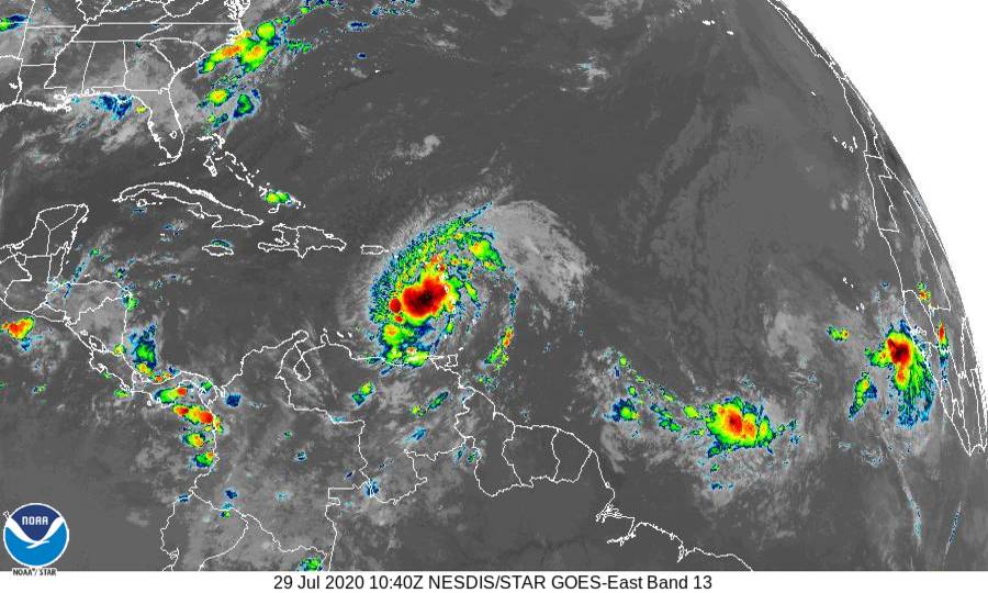
There are still uncertainties regarding the track of Potential TC # 9. As of early Wednesday, it was still difficult to locate a center, and its rapid forward speed is likely impeding the formation of a closed circulation — which affects the data going into computer models. Interaction with the mountains of Puerto Rico and Hispaniola (and possibly eastern Cuba), the location of the Saharan dust layer, and possible wind shear over the Florida Straits will all play a role. But the bottom line is that South Florida is likely to experience tropical storm conditions this weekend, and we need to prepare for that.
We should be topping off hurricane supplies now. By Friday evening, we should have secured any outside items that could become projectiles in a strong wind. We’ll need to monitor the progress and strength of this system from now through the weekend. While shutters won’t be necessary in a weak to moderate tropical storm, if what will be Isaias should strengthen beyond that point, you’ll need to have your shutters in place by Friday evening, well in advance of gusty conditions.
Disclaimer
Artificial Intelligence Disclosure & Legal Disclaimer
AI Content Policy.
To provide our readers with timely and comprehensive coverage, South Florida Reporter uses artificial intelligence (AI) to assist in producing certain articles and visual content.
Articles: AI may be used to assist in research, structural drafting, or data analysis. All AI-assisted text is reviewed and edited by our team to ensure accuracy and adherence to our editorial standards.
Images: Any imagery generated or significantly altered by AI is clearly marked with a disclaimer or watermark to distinguish it from traditional photography or editorial illustrations.
General Disclaimer
The information contained in South Florida Reporter is for general information purposes only.
South Florida Reporter assumes no responsibility for errors or omissions in the contents of the Service. In no event shall South Florida Reporter be liable for any special, direct, indirect, consequential, or incidental damages or any damages whatsoever, whether in an action of contract, negligence or other tort, arising out of or in connection with the use of the Service or the contents of the Service.
The Company reserves the right to make additions, deletions, or modifications to the contents of the Service at any time without prior notice. The Company does not warrant that the Service is free of viruses or other harmful components.


