

 South Florida will see sun and some showers on Saturday. The day features sun, some clouds, and periods of showers (with most widespread coverage in extreme northern Broward and Palm Beach counties). Some coastal flooding in low-lying areas is possible at high tides on Saturday and Sunday. Highs on Saturday will be in the mid 80s.
Don’t forget to set your clocks back one hour for the start of standard time early on Sunday morning, and enjoy the extra sleep.
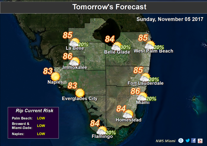 When you wake up on Sunday, you’ll find a mix of sun and clouds with quick showers moving through. Sunday’s highs will be in the mid 80s.
Monday will be drier and pleasant, with a nice mix of sun and clouds. Monday’s highs will be in the low to mid 80s.

The pattern continues on Tuesday, with sun and clouds and just the chance of a stray shower. Tuesday’s highs will be in the mid 80s.
Look for a pleasant mix of sun and clouds on Wednesday. Highs on Wednesday will be in the mid 80s.
 No development is expected in the tropics during the next few days. However, back in 1935 the weather forecast was much more worrisome. A late season hurricane approached from the very usual direction of east-northeast, making landfall near North Miami Beach. This was only two months after the much more well-known 1935 Labor Day hurricane that devastated the Keys. This November storm would be known as the “Yankee” or “Miami” hurricane due to its unusual approach.
Disclaimer
Artificial Intelligence Disclosure & Legal Disclaimer
AI Content Policy.
To provide our readers with timely and comprehensive coverage, South Florida Reporter uses artificial intelligence (AI) to assist in producing certain articles and visual content.
Articles: AI may be used to assist in research, structural drafting, or data analysis. All AI-assisted text is reviewed and edited by our team to ensure accuracy and adherence to our editorial standards.
Images: Any imagery generated or significantly altered by AI is clearly marked with a disclaimer or watermark to distinguish it from traditional photography or editorial illustrations.
General Disclaimer
The information contained in South Florida Reporter is for general information purposes only.
South Florida Reporter assumes no responsibility for errors or omissions in the contents of the Service. In no event shall South Florida Reporter be liable for any special, direct, indirect, consequential, or incidental damages or any damages whatsoever, whether in an action of contract, negligence or other tort, arising out of or in connection with the use of the Service or the contents of the Service.
The Company reserves the right to make additions, deletions, or modifications to the contents of the Service at any time without prior notice. The Company does not warrant that the Service is free of viruses or other harmful components.


")


