Home Weather Rain Expected This Afternoon; Watching Several Tropical Disturbances

Rain Expected This Afternoon; Watching Several Tropical Disturbances

rain

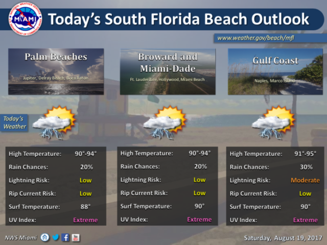
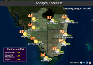
rainRain is on the way to South Florida on Saturday as we continue to watch the tropics. Saturday will start on the dry side, but look for clouds to build and storms to pop up in the afternoon as the sea breeze kicks in. Highs on Saturday will be in the low 90s at the coast and the mid 90s inland. Showers and storms will continue in the evening and overnight as a weak wave moves through.

Sunday will be rainy and cloudy, with passing showers and storms. Localized flooding is possible in vulnerable areas. Sunday’s highs will be near 90 degrees.

Monday will be more typical of our summer weather, with a few early showers, a mix of sun and clouds, and a few afternoon storms on the day of the partial eclipse. Highs on Monday will be in the low 90s. Our weather after Monday night depends on the tropics.

For now, we’ll say that Tuesday will be cloudy with increasing showers and storms as that wave we’ve been watching approaches. Highs on Tuesday will be near 90 degrees.

Look for stormy conditions to continue on Wednesday. Wednesday’s highs will be in the upper 80s.
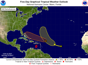
rainAs for the tropics, the wave in the central Atlantic that we’re watching has a medium chance of becoming a depression. It’s disorganized now and will encounter conditions that aren’t very favorable for development. But computer models indicate it will be in our vicinity by late Tuesday or Wednesday — so we’ll monitor it closely and prepare at least for drenching rains.

Tropical Storm Harvey is bringing heavy rain to Aruba, Bonaire, and Curacao. At 5 am Saturday, Harvey was located near 13.8 North, 65.9 West, and was moving west at 21 miles per hour. Maximum sustained winds were 40 miles per hour, but some strengthening is likely before Harvey reaches the Central American coast.

Finally, the wave in the eastern Atlantic has a low chance of developing by midweek.

Donna Thomas has studied hurricanes for two decades. She holds a PhD in history when her experience with Hurricane Andrew ultimately led her to earn a degree in broadcast meteorology from Mississippi State University. Donna spent 15 years at WFOR-TV (CBS4 in Miami-Fort Lauderdale), where she worked as a weather producer with hurricane experts Bryan Norcross and David Bernard. She also produced hurricane specials and weather-related features and news coverage, as well as serving as pool TV producer at the National Hurricane Center during the 2004 and 2005 seasons. Donna also served as a researcher on NOAA's Atlantic Hurricane Database Reanalysis Project. Donna specializes in Florida's hurricane history.