

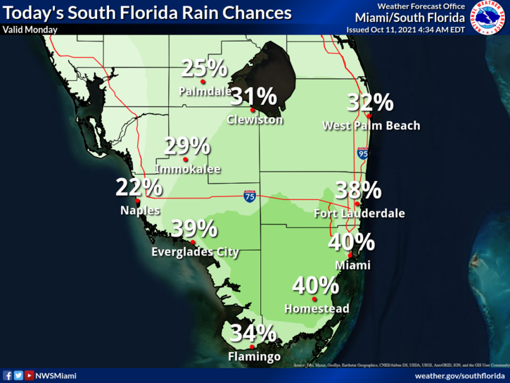
 The Columbus Day holiday features good sun in the morning and some showers with a storm or two in the afternoon, especially in the east coast metro area. A moderate risk of dangerous rip currents remains along the Palm Beach County coast. Highs on Monday will be mostly in the upper 80s.
LIVE RADAR 24/7 (Click Here Then Press Play)
Tuesday will bring plenty of sun to start and some showers and storms in the afternoon. Tuesday’s highs will be mostly in the upper 80s.
Wednesday will begin with lots of sun in the morning, and showers and a few storms will develop during the afternoon. Wednesday’s highs will be in the upper 80s.

Thursday will feature sunny skies in the morning and mid to late afternoon showers and storms. Thursday’s highs will be in the upper 80s.
Friday’s forecast calls for another sunny morning and some showers and storms in the mid to late afternoon hours. Highs on Friday will be in the upper 80s in the east coast metro area and near 90 degrees along the Gulf coast.
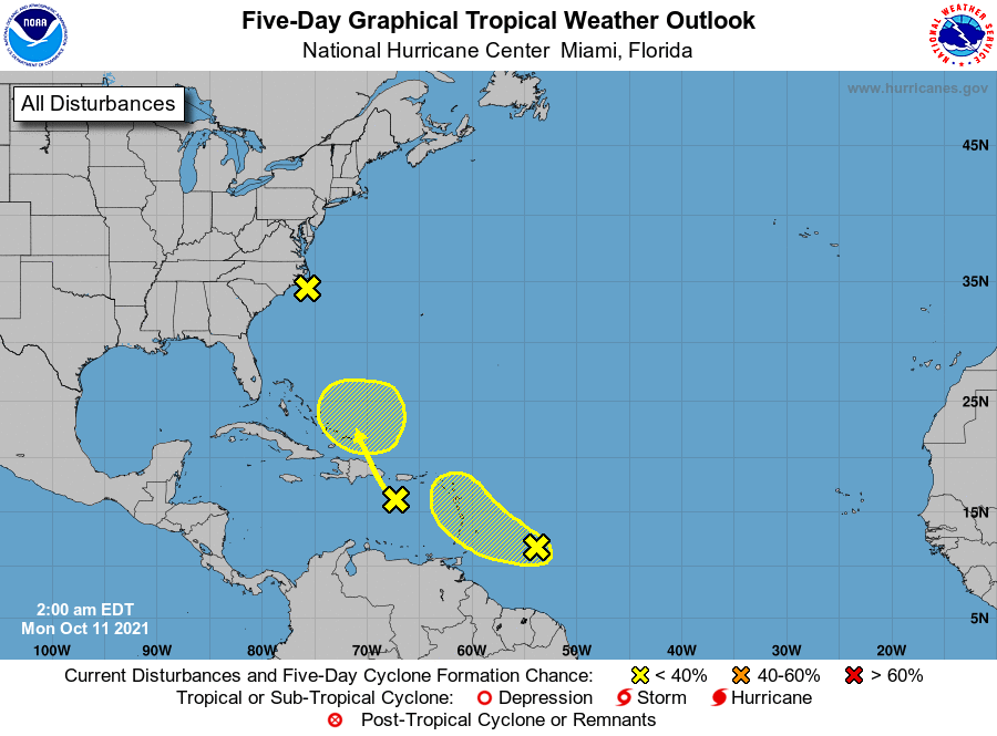 In the tropics, we’re watching a couple of tropical waves which currently have a low chance of development. The first is in the eastern Caribbean but will move into the southeastern Bahamas by mid to late week. This wave will bring heavy rain to portions of the Leeward Islands, Puerto Rico, and Hispaniola during the next day or so. The second wave is about 400 miles east of the Windward Islands. While upper level winds are forecast to limit development, this wave will bring gusty winds and heavy rain to the Lesser Antilles on Tuesday and the Virgin Islands and Puerto Rico on Wednesday.
Finally, the low off the North Carolina coast is not expected to become a subtropical depression but it will bring heavy rain to the North Carolina Outer Banks for the next day or so.
Disclaimer
Artificial Intelligence Disclosure & Legal Disclaimer
AI Content Policy.
To provide our readers with timely and comprehensive coverage, South Florida Reporter uses artificial intelligence (AI) to assist in producing certain articles and visual content.
Articles: AI may be used to assist in research, structural drafting, or data analysis. All AI-assisted text is reviewed and edited by our team to ensure accuracy and adherence to our editorial standards.
Images: Any imagery generated or significantly altered by AI is clearly marked with a disclaimer or watermark to distinguish it from traditional photography or editorial illustrations.
General Disclaimer
The information contained in South Florida Reporter is for general information purposes only.
South Florida Reporter assumes no responsibility for errors or omissions in the contents of the Service. In no event shall South Florida Reporter be liable for any special, direct, indirect, consequential, or incidental damages or any damages whatsoever, whether in an action of contract, negligence or other tort, arising out of or in connection with the use of the Service or the contents of the Service.
The Company reserves the right to make additions, deletions, or modifications to the contents of the Service at any time without prior notice. The Company does not warrant that the Service is free of viruses or other harmful components.


")

