

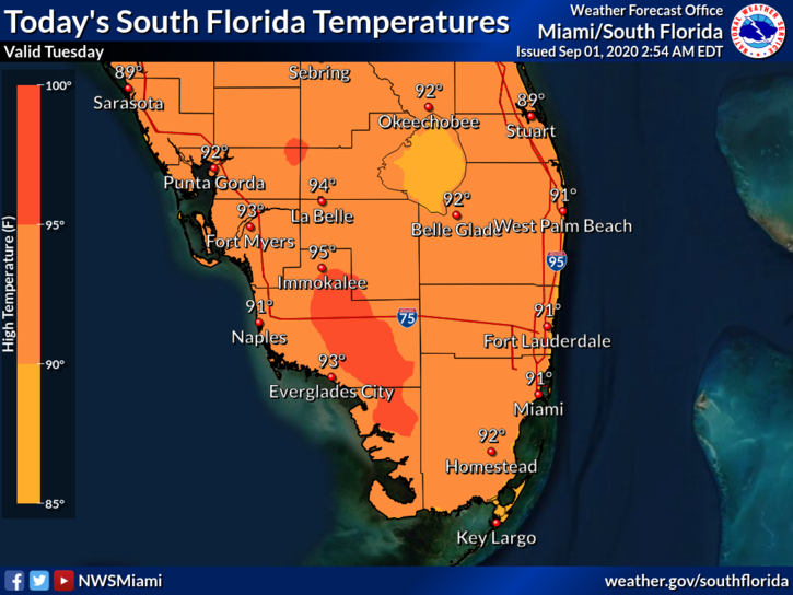
 Tuesday features plenty of hot sun and a few afternoon showers and storms as September begins. Tuesday’s highs will be in the low 90s, but it will feel about 10 degrees hotter.
LIVE RADAR 24/7 (Click Here Then Press Play)
Wednesday will bring mostly sunny skies and some showers in spots from late morning into the afternoon. Wednesday’s highs will be in the low 90s in the east coast metro area and the mid-90s along the Gulf coast.
Thursday will see good sun, a few clouds, and mid to late afternoon showers and storms along the Gulf coast, while the east coast metro area can expect good sun and a few showers and storms on a brisk ocean breeze. Thursday’s highs will be in the low to mid-90s.

Friday will feature mostly sunny skies to start and periods of showers and storms in the mid to late afternoon. The east coast will see a sometimes gusty ocean breeze. Friday’s highs will be in the low to mid-90s.
Saturday’s forecast includes sun, clouds, and periods of showers and storms. Highs on Saturday will be in the low 90s.
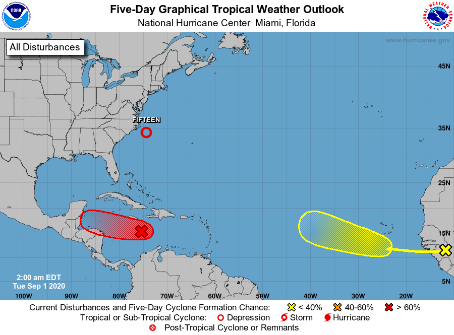 The tropical Atlantic is usually busy in September, and this year is likely to be no exception. For starters, the low off the Carolina coast is now Tropical Depression # 15. At 5 am Tuesday, TD # 15 was located near 34.1 North, 74.4 West, and was moving northeast at 13 miles per hour. Maximum sustained winds were 35 miles per hour. TD # 15 may not make it to tropical storm strength, and it will stay far from land. But a wave in the Caribbean has a high chance of becoming a depression, and it will affect portions of Central America. As of early Tuesday, this wave still did not have a closed circulation. And finally, a disturbance over western Africa will emerge into the eastern Atlantic in a couple of days. This wave has a low chance of developing in the next several days, but we’ll keep an eye on it as it moves over the Atlantic.
Disclaimer
Artificial Intelligence Disclosure & Legal Disclaimer
AI Content Policy.
To provide our readers with timely and comprehensive coverage, South Florida Reporter uses artificial intelligence (AI) to assist in producing certain articles and visual content.
Articles: AI may be used to assist in research, structural drafting, or data analysis. All AI-assisted text is reviewed and edited by our team to ensure accuracy and adherence to our editorial standards.
Images: Any imagery generated or significantly altered by AI is clearly marked with a disclaimer or watermark to distinguish it from traditional photography or editorial illustrations.
General Disclaimer
The information contained in South Florida Reporter is for general information purposes only.
South Florida Reporter assumes no responsibility for errors or omissions in the contents of the Service. In no event shall South Florida Reporter be liable for any special, direct, indirect, consequential, or incidental damages or any damages whatsoever, whether in an action of contract, negligence or other tort, arising out of or in connection with the use of the Service or the contents of the Service.
The Company reserves the right to make additions, deletions, or modifications to the contents of the Service at any time without prior notice. The Company does not warrant that the Service is free of viruses or other harmful components.


