

 Some big changes in Hurricane Dorian’s future track are big news in South Florida on Saturday. After reaching category 4 status overnight, Dorian is now moving a little faster on its way to the northwestern Bahamas. Computer models are now in agreement that Dorian will slow down in anticipation for a northward turn off the Florida east coast — possibly far enough from the coast to limit the impacts to the Gulf coast and the extreme southern part of the state. But we are still dealing with a powerful and extremely dangerous hurricane, so don’t let your guard down.
Keep informed with our interactive page
 At 8 am Saturday, Dorian was located near 25.8 North, 73 West, which is about 280 miles east of the northwestern Bahamas and 445 miles east of West Palm Beach. Maximum sustained winds were 145 miles per hour. Dorian was moving west-northwest at 12 miles per hour.
All of South Florida will see sustained tropical storm force winds starting on Sunday, even though the Gulf coast, the Keys, and the southern part of Miami-Dade are all out of the cone as of 5 am Saturday. Periods of hurricane force winds remain a distinct possibility on Monday into Tuesday in northern Miami-Dade and Broward. Because the Palm Beach County coast juts out slightly toward the Atlantic, it remains at higher risk for hurricane force winds than areas to the south.

A hurricane warning remains in effect for most of the northwestern Bahamas, except Andros Island, which is under a hurricane watch at 5 am. There are no U.S. watches or warnings at this time.
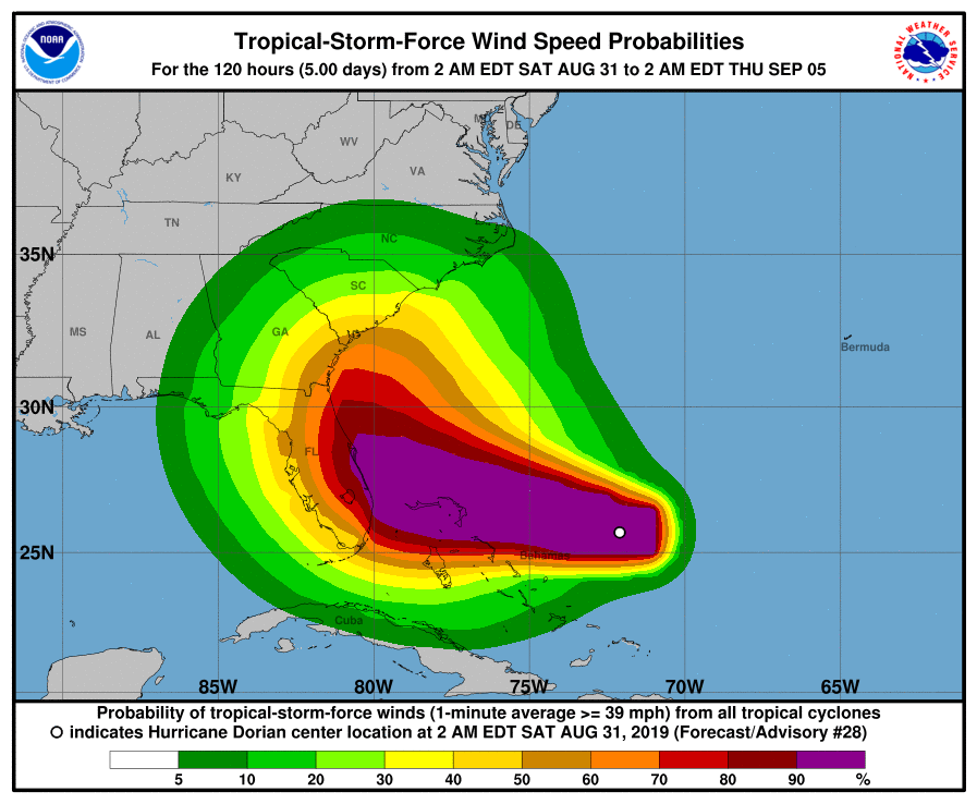 Bottom line for us — prepare for damaging winds and heavy rain, possibly as early as late Sunday morning on the east coast and late afternoon on Sunday along the Gulf coast. Be prepared to stay inside well into Tuesday, and expect to lose electricity for part of that period. Expect heavy rain, localized flooding, and coastal flooding. If you live in the east coast metro area, especially in northern Miami-Dade, Broward, and Palm Beach counties, put up your shutters today, so that you can finish the job well before tropical storm force winds arrive. Get as many of those last-minute preparations as possible on Saturday, while you’ll have plenty of time to do them.
 Our Saturday forecast calls for some sun, more clouds, and passing showers and storms. A high risk of dangerous rip currents is in place at the Atlantic beaches, and coastal flooding at high tides is possible. Highs on Saturday will be in the low 90s, but it will feel about 10 degrees hotter. Sunday will feature a mix of sun and clouds along the Gulf coast, but the east coast metro area will experience tropical storm force winds and periods of heavy rain. Sunday’s highs will be in the low 90s. All of South Florida will see damaging winds and heavy rain on Monday and Tuesday. Highs on Monday and Tuesday will be in the upper 80s. We should see a gradual improvement on Wednesday, but expect breezy conditions and periods of showers and storms. Highs on Wednesday will be in the upper 80s.
 As if there’s not enough happening, we’re also keeping track of a couple of additional features in the tropics. A disorganized area of showers east of Cuba has a low chance of development as it moves westward into the Gulf of Mexico. And in the eastern Atlantic, a wave southeast of the Cape Verde Islands has a medium chance of developing into a depression next week as it moves generally westward.


Disclaimer
Artificial Intelligence Disclosure & Legal Disclaimer
AI Content Policy.
To provide our readers with timely and comprehensive coverage, South Florida Reporter uses artificial intelligence (AI) to assist in producing certain articles and visual content.
Articles: AI may be used to assist in research, structural drafting, or data analysis. All AI-assisted text is reviewed and edited by our team to ensure accuracy and adherence to our editorial standards.
Images: Any imagery generated or significantly altered by AI is clearly marked with a disclaimer or watermark to distinguish it from traditional photography or editorial illustrations.
General Disclaimer
The information contained in South Florida Reporter is for general information purposes only.
South Florida Reporter assumes no responsibility for errors or omissions in the contents of the Service. In no event shall South Florida Reporter be liable for any special, direct, indirect, consequential, or incidental damages or any damages whatsoever, whether in an action of contract, negligence or other tort, arising out of or in connection with the use of the Service or the contents of the Service.
The Company reserves the right to make additions, deletions, or modifications to the contents of the Service at any time without prior notice. The Company does not warrant that the Service is free of viruses or other harmful components.


")
")
")


")
")
")