

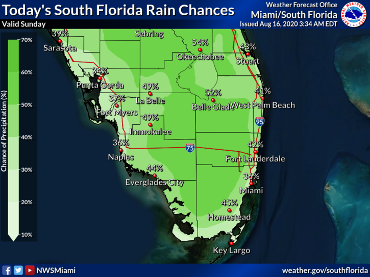
 Sunday features plenty of sun in the morning and developing clouds, showers, and storms in the afternoon. Highs on Sunday will be in the low 90s right at the coasts and the mid-90s elsewhere — but it will feel even hotter, so stay out of the sun and stay hydrated.
LIVE RADAR 24/7 (Click Here Then Press Play)
Monday will begin with mostly sunny skies, but showers and storms will develop by midafternoon. Monday’s highs will be in the low to mid-90s.
Look for more of the same on Tuesday — good sun in the morning and showers and storms in the afternoon. Tuesday’s highs will be mostly in the low 90s.

Wednesday will feature mostly sunny skies alternating with passing showers in the morning. Then widespread showers and storms will develop in the afternoon. Wednesday’s highs will be in the low 90s.
Thursday’s forecast calls for a mix of sun, showers, and storms. Highs on Thursday will be in the low 90s.
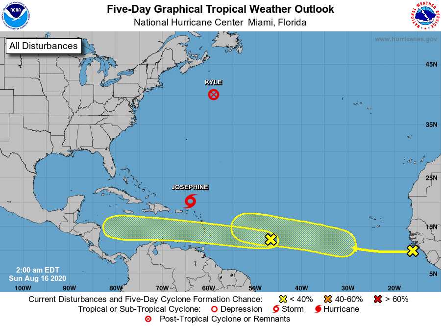 It’s really busy now in the tropics. We’ll start with the named systems, where there’s good news. Tropical Storm Josephine is losing steam north of the Leeward Islands. At 5 am on Sunday, Josephine was located near 20.3 North, 64.0 West, and was moving west-northwest at 15 miles per hour. Maximum sustained winds were 40 miles per hour, and Josephine is forecast to weaken more as it moves through an area of strong wind shear. Well to the north, Kyle has become extratropical in the open Atlantic. At 5 am Sunday, Kyle was about 545 miles southwest of Cape Race, Newfoundland. Maximum sustained winds were 40 miles per hour, and what’s left of Kyle will accelerate to the east before dissipating.

We’re keeping an eye on a couple of waves well to the south of Josephine and Kyle. The first wave is moving quickly to the west and will bring heavy rain and gusty winds to portions of the Lesser Antilles on Sunday night and Monday. This wave has a low chance of reaching depression strength until it reaches the cnetral to western Caribbean, but conditions will be more favorable for development at that time. Last but not least, a large wave has just emerged off the African coast. While this feature has a low chance of becoming a depression during the next several days, conditions will be more favorable after that. We’ll watch this one closely.
Disclaimer
Artificial Intelligence Disclosure & Legal Disclaimer
AI Content Policy.
To provide our readers with timely and comprehensive coverage, South Florida Reporter uses artificial intelligence (AI) to assist in producing certain articles and visual content.
Articles: AI may be used to assist in research, structural drafting, or data analysis. All AI-assisted text is reviewed and edited by our team to ensure accuracy and adherence to our editorial standards.
Images: Any imagery generated or significantly altered by AI is clearly marked with a disclaimer or watermark to distinguish it from traditional photography or editorial illustrations.
General Disclaimer
The information contained in South Florida Reporter is for general information purposes only.
South Florida Reporter assumes no responsibility for errors or omissions in the contents of the Service. In no event shall South Florida Reporter be liable for any special, direct, indirect, consequential, or incidental damages or any damages whatsoever, whether in an action of contract, negligence or other tort, arising out of or in connection with the use of the Service or the contents of the Service.
The Company reserves the right to make additions, deletions, or modifications to the contents of the Service at any time without prior notice. The Company does not warrant that the Service is free of viruses or other harmful components.


