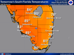
Thursday features lots of clouds and showers around South Florida. The east coast metro area will see gusty winds at times and some storms developing in the afternoon. Heavy rain and localized flooding are possible in spots. Look for an elevated risk of dangerous rip currents at the Atlantic beaches. Highs on Thursday will be in the upper 80s right at the coasts and in the Keys, while temperatures will peak around the 90 degree mark elsewhere in South Florida.
LIVE RADAR 24/7 (Click Here Then Press Play)
Friday will bring a mix of sun, clouds, and periods of showers and storms. Friday’s highs will be mostly in the low 90s in the east coast metro area and in the upper 80s along the Gulf coast and in the Keys.
Saturday will feature a mostly sunny morning and maybe an early shower in the eastern part of South Florida, but some storms will pop up in the afternoon. The western portion of the area will see sunny skies in the morning and some afternoon showers in spots. Saturday’s highs will be mostly in the low 90s in the east coast metro area and in the upper 80s along the Gulf coast and in the Keys.
Sunday will start with good sun, some clouds, and a few passing showers in the east coast metro area, but storms will move in during the afternoon. The Gulf coast will be sunny in the morning with some clouds and showers in the afternoon. Sunday’s highs will be in the low 90s.
Monday’s forecast calls for a summertime mix of sun, clouds, showers, and storms. Highs on Monday will be in the low 90s.
In the northeastern Atlantic, the low we’ve been watching has moved into an area of colder waters and is unlikely to develop. The tropical Atlantic is quiet right now.


