

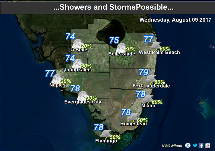
 South Florida will be hot again on Tuesday, but rain is on the way tonight. We’ll also need to watch the tropics for the next few days for potential development of that wave we’ve been watching. Here at home, Wednesday features a mix of sun and clouds and a shower or two, but we’ll see showers move in during the evening as some tropical moisture moves in. A high risk of rip currents remains in place at the Atlantic beaches through at least Wednesday evening. Highs on Wednesday will be in the low 90s.
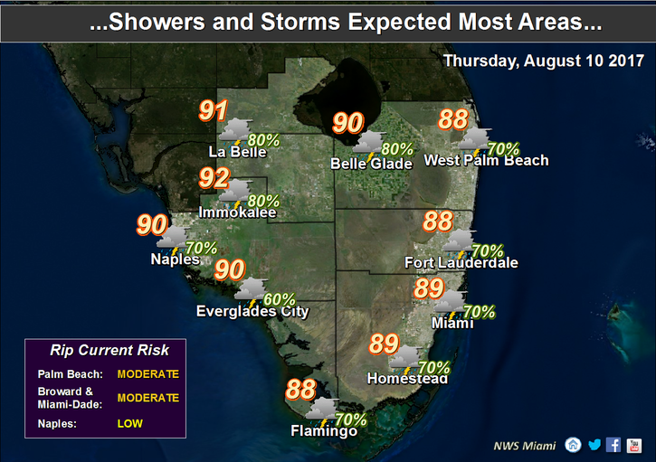 Thursday will bring clouds and passing showers and storms. Thursday’s highs will be mostly in the upper 80s.
Clouds, showers, and storms will linger on Friday, but we’ll see a bit of sun at times. Highs on Friday will be near 90 degrees.
Our weekend weather will depend in part on developments in the tropics, but for now we’ll say that Saturday and Sunday will feature a few early showers, a mix of sun and clouds, and an afternoon storm in spots. Look for highs on both days to be in the low 90s.

 Our weather will depend on what happens to the wave we’ve been watching for some time. Right now, it’s about 500 miles east of the Lesser Antilles and is moving west-northwest at about 15 miles per hour. It has a medium chance of developing into a depression this weekend or early next week. Computer models indicate a track east of the Bahamas, but just how close and how strong a system it is will determine whether we’ll see stormy conditions late in the weekend or early next week. We’ll all need to keep an eye on it until it’s well to our north.
Tropical Storm Franklin is approaching the east coast of Mexico. At 5 am, Franklin was located near 20.4 North, 88.5 West, and was moving west at 13 miles per hour. Maximum sustained winds were 65 miles per hour. Franklin is expected to reach hurricane strength before making a second landfall late on Wednesday or early Thursday. Flash flooding and mudslides are possible when the system moves into the mountainous areas of Mexico.
Disclaimer
Artificial Intelligence Disclosure & Legal Disclaimer
AI Content Policy.
To provide our readers with timely and comprehensive coverage, South Florida Reporter uses artificial intelligence (AI) to assist in producing certain articles and visual content.
Articles: AI may be used to assist in research, structural drafting, or data analysis. All AI-assisted text is reviewed and edited by our team to ensure accuracy and adherence to our editorial standards.
Images: Any imagery generated or significantly altered by AI is clearly marked with a disclaimer or watermark to distinguish it from traditional photography or editorial illustrations.
General Disclaimer
The information contained in South Florida Reporter is for general information purposes only.
South Florida Reporter assumes no responsibility for errors or omissions in the contents of the Service. In no event shall South Florida Reporter be liable for any special, direct, indirect, consequential, or incidental damages or any damages whatsoever, whether in an action of contract, negligence or other tort, arising out of or in connection with the use of the Service or the contents of the Service.
The Company reserves the right to make additions, deletions, or modifications to the contents of the Service at any time without prior notice. The Company does not warrant that the Service is free of viruses or other harmful components.


")