

South Florida will be hot and mostly dry on Sunday, while hundreds of miles to our north, the catastrophic flooding from Florence continues to plague the Carolinas.
 Our Sunday features hot sun, some clouds, and maybe a stray shower or storm (especially well inland). A moderate risk of rip currents is in place at the beaches of Palm Beach county as seas begin to calm down after the thrashing from Florence along much of the eastern seaboard. Highs on Sunday will be in the low 90s.
Monday will bring sun, clouds, and a shower or storm in spots during the afternoon. Monday’s highs will be in the low 90s.
Look for a few more showers to pop up on Tuesday, but we’ll also see sun and clouds. Tuesday’s highs will be near 90 degrees.
Wednesday will feature sun, clouds, a few early east coast showers, and afternoon showers and storms along the sea breezes. Wednesday’s highs will be near 90 degrees.
More moisture will seep in on Thursday, so we’ll see passing showers and storms in spots. Highs on Thursday will be near 90 degrees.
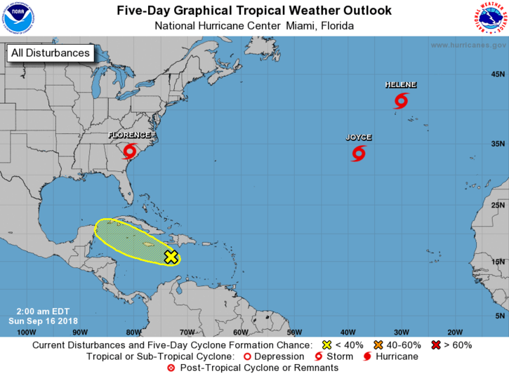 Florence is now a depression, but one that continues to dump huge amounts of rain on North and South Carolina. At 5 am Sunday, Florence was located near 33.8 North, 81.4 West, about 20 miles from Columbia, South Carolina. Maximum sustained winds were 35 miles per hour, and Florence was moving west at 8 miles per hour. Many locations have already received more than 20 inches of rain, and flooding from rivers will add to the misery from this deadly system.
In the far Atlantic, Tropical Storm Helene is transitioning into an extratropical low. At 5 am Sunday, Helene was located near 42.5 North, 28.4 West, and was zooming northeast at 25 miles per hour. Maximum sustained winds were 50 miles per hour. And Tropical Storm Joyce is barely hanging on, with maximum sustained winds of 40 miles per hour early Sunday. At 5 am, Joyce was located near 34.0 North, 36.1 West, and was moving east-northeast at 17 miles per hour. Joyce poses no threat to land.
Finally, the remnants of Isaac have a low chance of redeveloping in the central Caribbean during the next few days — after which conditions will be quite hostile.
Disclaimer
Artificial Intelligence Disclosure & Legal Disclaimer
AI Content Policy.
To provide our readers with timely and comprehensive coverage, South Florida Reporter uses artificial intelligence (AI) to assist in producing certain articles and visual content.
Articles: AI may be used to assist in research, structural drafting, or data analysis. All AI-assisted text is reviewed and edited by our team to ensure accuracy and adherence to our editorial standards.
Images: Any imagery generated or significantly altered by AI is clearly marked with a disclaimer or watermark to distinguish it from traditional photography or editorial illustrations.
General Disclaimer
The information contained in South Florida Reporter is for general information purposes only.
South Florida Reporter assumes no responsibility for errors or omissions in the contents of the Service. In no event shall South Florida Reporter be liable for any special, direct, indirect, consequential, or incidental damages or any damages whatsoever, whether in an action of contract, negligence or other tort, arising out of or in connection with the use of the Service or the contents of the Service.
The Company reserves the right to make additions, deletions, or modifications to the contents of the Service at any time without prior notice. The Company does not warrant that the Service is free of viruses or other harmful components.


")

