

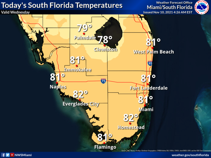
 Wednesday starts with a few quick east coast showers. Then the day features good sun to start with building clouds and some spotty showers in the afternoon. A high risk of dangerous rip currents remains at the Atlantic beaches, and minor coastal flooding is possible near high tides. Highs on Wednesday will be in the low 80s.
LIVE RADAR 24/7 (Click Here Then Press Play)
Veterans Day will see some sun, plenty of clouds, and periods of showers. Thursday’s highs will be in the low 80s.
Friday will bring clouds, showers, and some storms as another front slowly moves into our area. Friday’s highs will be in the mid-80s in the east coast metro area and the low 80s along the Gulf coast.

Saturday will feature clouds, showers, and storms to start. Then look for clearing skies.. Saturday’s highs will be near the 80-degree mark.
Sunday’s forecast calls for sunny skies and a cool breeze as the front clears South Florida. Highs on Sunday will be in the mid-70s.
A strong non-tropical low about 400 miles northeast of Bermuda has a medium chance of developing into a subtropical storm in the next few days. This system, whether or not it develops, will remain in the open waters of the central Atlantic.
Disclaimer
Artificial Intelligence Disclosure & Legal Disclaimer
AI Content Policy.
To provide our readers with timely and comprehensive coverage, South Florida Reporter uses artificial intelligence (AI) to assist in producing certain articles and visual content.
Articles: AI may be used to assist in research, structural drafting, or data analysis. All AI-assisted text is reviewed and edited by our team to ensure accuracy and adherence to our editorial standards.
Images: Any imagery generated or significantly altered by AI is clearly marked with a disclaimer or watermark to distinguish it from traditional photography or editorial illustrations.
General Disclaimer
The information contained in South Florida Reporter is for general information purposes only.
South Florida Reporter assumes no responsibility for errors or omissions in the contents of the Service. In no event shall South Florida Reporter be liable for any special, direct, indirect, consequential, or incidental damages or any damages whatsoever, whether in an action of contract, negligence or other tort, arising out of or in connection with the use of the Service or the contents of the Service.
The Company reserves the right to make additions, deletions, or modifications to the contents of the Service at any time without prior notice. The Company does not warrant that the Service is free of viruses or other harmful components.


")
")
