Heavy rainfall will continue to raise flood risks for millions from Washington D.C. to Boston, just days after the region endured 100-degree heat during the holiday weekend’s historic heat dome.
AccuWeather forecasts repeated heavy downpours will raise the risk of significant flash flooding from northeastern Pennsylvania to southern New England through Tuesday as ‘training storms’ repeatedly track over the same areas. Rainfall rate may exceed 2 inches per hour in the heaviest bouts.
“When we talk about ‘training storms,’ think of it like train cars all passing over the same track. As one storm cell moves through, another forms right behind it and follows the same path,” said AccuWeather expert meteorologist Tyler Roys. “Instead of rain spreading out and moving on, the same areas keep getting hit over and over and you can see dramatic differences in rain amounts in a small area. That’s when you get extreme rainfall totals in a short time, and it’s one of the biggest drivers of flash flooding.”
Repeated rounds of thunderstorms could produce rainfall rates exceeding 2 inches per hour, quickly overwhelming drainage systems, and increasing the risk of dangerous flash flooding in vulnerable areas. Some in eastern Pennsylvania and New York have already recorded as much as 7 inches of rain since Sunday.

“While all flash flooding can be life-threatening, rain rates of 1-3 inches per hour are especially dangerous and can result in rapidly escalating flash-flooding risks where people may need to immediately move to higher ground. In such extreme rain rates, areas of steep terrain, places near creeks, streams and other waterways and in the urban environments where there are many concrete surfaces such as streets and sidewalks, runoff from heavy rain can be enhanced, greatly increasing the risk for serious flash flooding,” added AccuWeather Chief Meteorologist Jonathan Porter.
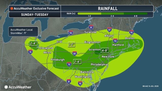
AccuWeather forecasts 2-8 inches of rain across the entire region through Tuesday.
- 1–2 inches: Hudson Valley (NY) through central and southern New England
- 2–4 inches: Western Pennsylvania through much of the I-95 corridor
- AccuWeather Local StormMax™: 9 inches, primarily along the I-84 and I-95 corridors
Disclaimer
Artificial Intelligence Disclosure & Legal Disclaimer
AI Content Policy.
To provide our readers with timely and comprehensive coverage, South Florida Reporter uses artificial intelligence (AI) to assist in producing certain articles and visual content.
Articles: AI may be used to assist in research, structural drafting, or data analysis. All AI-assisted text is reviewed and edited by our team to ensure accuracy and adherence to our editorial standards.
Images: Any imagery generated or significantly altered by AI is clearly marked with a disclaimer or watermark to distinguish it from traditional photography or editorial illustrations.
General Disclaimer
The information contained in South Florida Reporter is for general information purposes only.
South Florida Reporter assumes no responsibility for errors or omissions in the contents of the Service. In no event shall South Florida Reporter be liable for any special, direct, indirect, consequential, or incidental damages or any damages whatsoever, whether in an action of contract, negligence or other tort, arising out of or in connection with the use of the Service or the contents of the Service.
The Company reserves the right to make additions, deletions, or modifications to the contents of the Service at any time without prior notice. The Company does not warrant that the Service is free of viruses or other harmful components.