UPDATED 11AM: Danny has strengthened quickly Thursday morning and is now a minimal hurricane, the first of the 2015 Atlantic season. As of 11 am, Danny was located near 12.5 North, 44.8 West and was moving west-northwest at a slightly faster 12 miles per hour. Maximum sustained winds were 75 miles per hour. Danny still has to contend with dry air and, in a couple of days, wind shear. Danny’s strength is likely to fluctuate through the weekend, and it could be back to tropical storm status by Monday, when it’s expected to reach the Leeward Islands. In any event, Danny should shift to a more westerly track before then. The National Hurricane Center forecasts Danny to be a tropical storm near or over Puerto Rico on Tuesday, but some major models indicate that Danny may weaken into an open wave by that point. In any case, we in South Florida will watch it closely.
Elsewhere in the tropics, both an area of showers and storms south of Bermuda and a wave coming off Africa have a low chance of developing over the next couple of days, according to the National Hurricane Center.
The National Hurricane Center says Danny is now a Hurricane. This is the first hurricane of the 2015 season.
Here is the latest track from the NHC:
11:00 AM AST Thu Aug 20
Location: 12.5°N 44.8°W
Moving: WNW at 12 mph
Min pressure: 992 mb
Max sustained: 75 mph
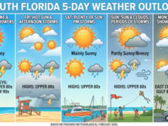
Our pattern will hold through the weekend, with a few morning showers and afternoon storms mostly inland, but with highs in the low to mid 90s. Monday and Tuesday will bring some afternoon storms and highs mostly in the low 90s.
=================
By Donna Thomas, SouthFloridaReporter.com Meteorologist, Aug 20, 2015 – South Florida will be steamy hot again on Thursday, with a few early showers and a stray afternoon storm to dampen the sizzle briefly. Thursday’s highs will reach the low 90s but feel about 10 degrees warmer.

In the tropics, Tropical Storm Danny looks better organized on satellite early Thursday morning. As of 5 am, Danny was located near 12.2 North, 43.7 West and was moving west at 10 miles per hour. Maximum sustained winds remained at 50 miles per hour, but some strengthening is possible, and the National Hurricane Center is still forecasting Danny to reach minimal hurricane status Friday or early Saturday. Danny should begin a west-northwestward movement soon but will again shift to a westward track by the weekend. Danny will continue to encounter dry air and will be affected by wind shear. Two major models show that Danny could degenerate into a tropical wave near or over the Leeward Islands late in the weekend or on Monday, but this is uncertain. We’ll keep a close eye on Danny to see just where it (or its remnants) are headed and what that could mean for South Florida.
Disclaimer
Artificial Intelligence Disclosure & Legal Disclaimer
AI Content Policy.
To provide our readers with timely and comprehensive coverage, South Florida Reporter uses artificial intelligence (AI) to assist in producing certain articles and visual content.
Articles: AI may be used to assist in research, structural drafting, or data analysis. All AI-assisted text is reviewed and edited by our team to ensure accuracy and adherence to our editorial standards.
Images: Any imagery generated or significantly altered by AI is clearly marked with a disclaimer or watermark to distinguish it from traditional photography or editorial illustrations.
General Disclaimer
The information contained in South Florida Reporter is for general information purposes only.
South Florida Reporter assumes no responsibility for errors or omissions in the contents of the Service. In no event shall South Florida Reporter be liable for any special, direct, indirect, consequential, or incidental damages or any damages whatsoever, whether in an action of contract, negligence or other tort, arising out of or in connection with the use of the Service or the contents of the Service.
The Company reserves the right to make additions, deletions, or modifications to the contents of the Service at any time without prior notice. The Company does not warrant that the Service is free of viruses or other harmful components.


