

 Monday features some morning sun, but showers and storms will develop, mostly in the afternoon. Storms could be slow-moving, so heavy rain and localized flooding are possible, especially near the Gulf coast. Highs on Monday will be near 90 degrees.
LIVE RADAR 24/7 (Click Here Then Press Play)
Tuesday will bring a mix of sun and clouds during the first half of the day, with showers and storms developing in the mid to late afternoon. Tuesday’s highs will be near 90 degrees in the east coast metro area and the low 90s along the Gulf coast.
Wednesday will repeat the pattern — sun and clouds in the morning and periods of showers and storms in the afternoon. Wednesday’s highs will be in the upper 80s in the east coast metro area and the low 90s along the Gulf coast.

Thursday will feature mostly sunny skies until showers and storms pop up again, mostly in the afternoon hours. Thursday’s highs will be in the upper 80s in the east coast metro area and the low 90s along the Gulf coast.
Friday’s forecast calls for good sun and some clouds alternating with plenty of showers and storms. Look for breezy conditions in the east coast metro area and an elevated rip current risk at the Atlantic beaches. Highs on Friday will be in the upper 80s in the east coast metro area and the low 90s along the Gulf coast.
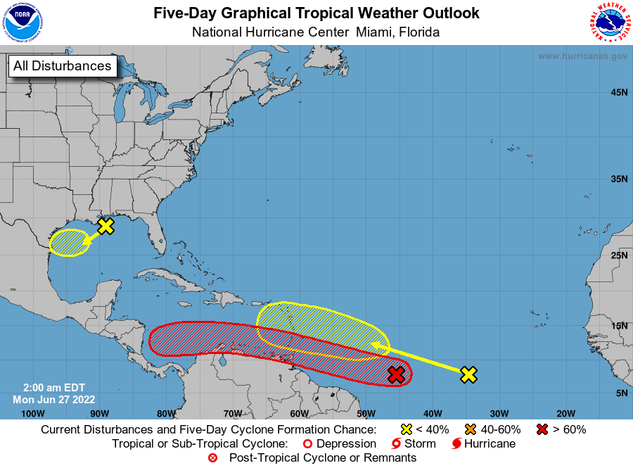 In the tropics, the wave approaching the Windward Islands has a high chance of becoming a depression as it tracks across the Caribbean. The area of low pressure off the northern Gulf coast has a low chance of development as it moves slowly westward in the direction of southern Texas and northern Mexico. And a wave in the eastern Atlantic has a low chance of becoming a depression in the next five days as it moves west-northwestward.
Disclaimer
Artificial Intelligence Disclosure & Legal Disclaimer
AI Content Policy.
To provide our readers with timely and comprehensive coverage, South Florida Reporter uses artificial intelligence (AI) to assist in producing certain articles and visual content.
Articles: AI may be used to assist in research, structural drafting, or data analysis. All AI-assisted text is reviewed and edited by our team to ensure accuracy and adherence to our editorial standards.
Images: Any imagery generated or significantly altered by AI is clearly marked with a disclaimer or watermark to distinguish it from traditional photography or editorial illustrations.
General Disclaimer
The information contained in South Florida Reporter is for general information purposes only.
South Florida Reporter assumes no responsibility for errors or omissions in the contents of the Service. In no event shall South Florida Reporter be liable for any special, direct, indirect, consequential, or incidental damages or any damages whatsoever, whether in an action of contract, negligence or other tort, arising out of or in connection with the use of the Service or the contents of the Service.
The Company reserves the right to make additions, deletions, or modifications to the contents of the Service at any time without prior notice. The Company does not warrant that the Service is free of viruses or other harmful components.


