 |
|
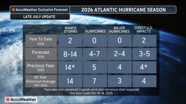
A tropical depression could form if a cluster of thunderstorms organizes into an area of low pressure that separates from the front and develops a warm-core circulation rather than relying on temperature contrasts along the front. The AccuWeather Atlantic Hurricane Forecast Latest AccuWeather hurricane experts are maintaining its previous forecast of 8-14 named storms, 4-7 hurricanes, 2-4 major hurricanes and 3-5 direct U.S. impacts this season. The forecast was last updated in early July. Already this season, Tropical Storm Arthur, and Tropical Storm Bertha have caused heavy rain and flooding across the Gulf region. What AccuWeather Expert Meteorologists Are Tracking
AccuWeather RealImpact™ Scale for Hurricanes |

Disclaimer
Artificial Intelligence Disclosure & Legal Disclaimer
AI Content Policy.
To provide our readers with timely and comprehensive coverage, South Florida Reporter uses artificial intelligence (AI) to assist in producing certain articles and visual content.
Articles: AI may be used to assist in research, structural drafting, or data analysis. All AI-assisted text is reviewed and edited by our team to ensure accuracy and adherence to our editorial standards.
Images: Any imagery generated or significantly altered by AI is clearly marked with a disclaimer or watermark to distinguish it from traditional photography or editorial illustrations.
General Disclaimer
The information contained in South Florida Reporter is for general information purposes only.
South Florida Reporter assumes no responsibility for errors or omissions in the contents of the Service. In no event shall South Florida Reporter be liable for any special, direct, indirect, consequential, or incidental damages or any damages whatsoever, whether in an action of contract, negligence or other tort, arising out of or in connection with the use of the Service or the contents of the Service.
The Company reserves the right to make additions, deletions, or modifications to the contents of the Service at any time without prior notice. The Company does not warrant that the Service is free of viruses or other harmful components.