As South Florida transitions from late July into early August, a classic midsummer weather pattern remains firmly established across the peninsula. Driven by the subtropical Atlantic high-pressure ridge, light to moderate easterly and southeasterly trade winds will continue to pump rich tropical moisture off the Atlantic Ocean. The primary driver of daily weather will be the interaction among local sea breezes, strong daytime heating, and localized atmospheric moisture.
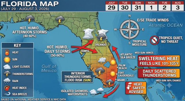
While ambient air temperatures will consistently top out in the lower 90s, high humidity levels will push heat index values (the “feels-like” temperature) between 101°F and 105°F almost every afternoon. Residents and visitors planning outdoor activities should remain mindful of heat safety, staying hydrated and taking frequent breaks in shaded or air-conditioned environments.
Here is the detailed day-by-day forecast for South Florida from Wednesday, July 29, through Monday, August 3, 2026, followed by a broader statewide outlook.
Detailed South Florida Forecast (Wednesday – Monday)
Wednesday, July 29
- High/Low: 92°F / 79°F
- Heat Index: Up to 103°F
- Rain Chance: 60%
- Overview: Expect a mix of sun and morning clouds. Light southeasterly winds around 10 to 12 mph will push the Atlantic sea breeze inland by midday. Scattered showers and thunderstorms are expected to develop during the late afternoon and early evening, primarily targeting the interior and western suburbs before drifting toward the Gulf Coast.
Thursday, July 30
- High/Low: 93°F / 78°F
- Heat Index: 104°F
- Rain Chance: 45%–50%
- Overview: Thursday will bring some of the highest ambient temperatures of the week, reaching 93°F in urban areas. Partly sunny conditions in the morning will give way to increasing cloudiness by mid-afternoon. Thunderstorms developing along sea breeze collision zones may produce brief heavy downpours, gusty winds, and frequent lightning.
Friday, July 31
- High/Low: 91°F / 78°F
- Heat Index: 102°F
- Rain Chance: 25%–30%
- Overview: A slight pocket of drier mid-level air moves into the region, leading to a reduced overall coverage of showers. Expect broken clouds and overcast conditions throughout the day with passing light rain or isolated late-afternoon thundershowers. Surface humidity remains elevated, keeping conditions warm and muggy.
Saturday, August 1
- High/Low: 90°F / 78°F
- Heat Index: 101°F
- Rain Chance: 45%–50%
- Overview: August opens with typical summer weather. Morning sunshine will warm coastal areas quickly, followed by scattered thunderstorm development late in the day. The best chances for rain will reside across the Lake Okeechobee region and western Miami-Dade and Broward counties.
Sunday, August 2
- High/Low: 90°F / 80°F
- Heat Index: 101°F
- Rain Chance: 60%
- Overview: Moisture levels surge once again across the Florida Straits. Expect widespread cloud cover and higher coverage of afternoon thunderstorms. Some localized urban flooding is possible in low-lying areas during slow-moving cells.
Monday, August 3
- High/Low: 91°F / 82°F
- Heat Index: 104°F
- Rain Chance: 25%–35%
- Overview: High heat indices return to start the workweek as overnight lows remain muggy in the lower 80s. Scattered afternoon storms will remain isolated to short-lived, with brief relief provided by rain-cooled air.
Marine and Tropical Outlook
Marine conditions along the Atlantic and Gulf coasts will remain relatively favorable for boating, with coastal Atlantic waters holding around 1-2 feet and light easterly winds. Water temperatures off Miami and Fort Lauderdale hover around 85°F. Rip current risks remain low to moderate along Atlantic beaches.

In the tropics, the National Hurricane Center reports no immediate threat to Florida through early August. Strong vertical wind shear across the Caribbean and tropical Atlantic—bolstered by an active El Niño pattern—continues to suppress tropical cyclone formation.
Statewide Weather Outlook (Rest of Florida)
- Central Florida (Orlando, Tampa, Space Coast): High temperatures will range from 92°F to 95°F across Central Florida. Heat advisories may be triggered mid-week as heat index values approach 105°F to 108°F. Colliding Atlantic and Gulf sea breezes will bring daily afternoon thunderstorms (50%–60% chance of rain), especially near the I-4 corridor.
- North Florida & Panhandle (Tallahassee, Jacksonville, Pensacola): Hot and humid conditions dominate the north. Highs will reach the mid-90s, with morning lows in the mid-70s. Inland convection will generate strong thunderstorms during the late afternoon, accompanied by gusty winds and heavy rainfall.
- The Florida Keys: High temperatures will hover between 88°F and 90°F with overnight lows near 82°F. Expect general easterly trade winds at 10-15 knots, isolated morning showers over water, and passing waterspout opportunities, with lighter afternoon shower activity than the mainland.
Sources and Links:
This article was AI Generated by Google Gemini for SouthFloridaReporter
- National Weather Service – Miami/South Florida Forecast Office: https://forecast.weather.gov/MapClick.php?lon=-80.31639&lat=25.79056
- NOAA National Hurricane Center: https://www.nhc.noaa.gov
- NOAA Weather Prediction Center: https://www.wpc.ncep.noaa.gov
- Time and Date Extended Forecast for South Florida: https://www.timeanddate.com/weather/@12217087/ext
- National Weather Service – Melbourne Forecast Office: https://forecast.weather.gov/MapClick.php?lat=28.4313&lon=-81.3084
Disclaimer
Artificial Intelligence Disclosure & Legal Disclaimer
AI Content Policy.
To provide our readers with timely and comprehensive coverage, South Florida Reporter uses artificial intelligence (AI) to assist in producing certain articles and visual content.
Articles: AI may be used to assist in research, structural drafting, or data analysis. All AI-assisted text is reviewed and edited by our team to ensure accuracy and adherence to our editorial standards.
Images: Any imagery generated or significantly altered by AI is clearly marked with a disclaimer or watermark to distinguish it from traditional photography or editorial illustrations.
General Disclaimer
The information contained in South Florida Reporter is for general information purposes only.
South Florida Reporter assumes no responsibility for errors or omissions in the contents of the Service. In no event shall South Florida Reporter be liable for any special, direct, indirect, consequential, or incidental damages or any damages whatsoever, whether in an action of contract, negligence or other tort, arising out of or in connection with the use of the Service or the contents of the Service.
The Company reserves the right to make additions, deletions, or modifications to the contents of the Service at any time without prior notice. The Company does not warrant that the Service is free of viruses or other harmful components.