

 Tuesday features periods of showers and storms, with some morning sun along the Gulf coast and mostly clouds in the east coast metro area. Heavy rain is possible, and so is localized flooding. A moderate risk of dangerous rip currents remains at the Atlantic beaches. Highs on Tuesday will be in the mid-80s in the east coast metro area and near 90 degrees along the Gulf coast.
LIVE RADAR 24/7 (Click Here Then Press Play)
 Wednesday will bring some sun in the morning and plenty of showers and storms during the mid to late afternoon. Wednesday’s highs will be in the mid-80s in the east coast metro area and near 90 degrees along the Gulf coast.
Thursday will feature a mix of sun and clouds with afternoon storms in the east coast metro area, while the Gulf coast will be sunny until some storms develop in the mid to late afternoon. Thursday’s highs will be in the upper 80s.

Friday will be cloudy with periods of showers and storms. Heavy rain is possible, along with localized flooding. Look for breezy conditions along the Gulf coast and a stormy evening throughout South Florida. Friday’s highs will be in the mid-80s.
The forecast for Saturday will depend on the tropics. For now, we’ll say that Saturday will be stormy and breezy. Heavy rain and localized flooding will be possible. Highs on Saturday will be in the mid-80s.
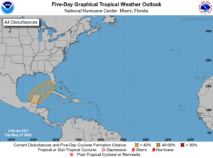
We’re watching the tropics, a low is expected to form near the Yucatan in the next few days. This low will include moisture from Tropical Storm Agatha, which is currently centered over southern Mexico. Computer models indicate this low is likely to move into the southwestern Gulf of Mexico and could become the first tropical depression of the 2022 Atlantic hurricane season. The National Hurricane Center currently gives this soon-to-form system a medium chance of development.
For South Florida, a lot will depend on where this potential tropical system actually forms and how much time it spends over warm waters before it approaches our vicinity. Whatever it does, this system is likely to bring heavy rain and gusty winds to South Florida late in the week. It’s a reminder that hurricane season is here.
Disclaimer
Artificial Intelligence Disclosure & Legal Disclaimer
AI Content Policy.
To provide our readers with timely and comprehensive coverage, South Florida Reporter uses artificial intelligence (AI) to assist in producing certain articles and visual content.
Articles: AI may be used to assist in research, structural drafting, or data analysis. All AI-assisted text is reviewed and edited by our team to ensure accuracy and adherence to our editorial standards.
Images: Any imagery generated or significantly altered by AI is clearly marked with a disclaimer or watermark to distinguish it from traditional photography or editorial illustrations.
General Disclaimer
The information contained in South Florida Reporter is for general information purposes only.
South Florida Reporter assumes no responsibility for errors or omissions in the contents of the Service. In no event shall South Florida Reporter be liable for any special, direct, indirect, consequential, or incidental damages or any damages whatsoever, whether in an action of contract, negligence or other tort, arising out of or in connection with the use of the Service or the contents of the Service.
The Company reserves the right to make additions, deletions, or modifications to the contents of the Service at any time without prior notice. The Company does not warrant that the Service is free of viruses or other harmful components.


