

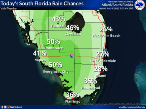
 Tuesday features plenty of sun and a few mostly east coast clouds in the morning as a bit of moisture moves in. A few showers and maybe a storm will be back in the afternoon, especially along the Gulf Coast and in the interior. Highs on Tuesday will be in the low 90s but feel like the 100s.
LIVE RADAR 24/7 (Click Here Then Press Play)
Wednesday will bring the return of hazy sun. An afternoon shower or storm will be possible in spots, especially near the Gulf coast. Wednesday’s highs will be in the low 90s.
Thursday will feature lots of sun with just the chance of an afternoon storm in spots. Thursday’s highs will be in the low 90s.

Friday will see mostly sunny skies and a few afternoon showers with maybe a storm or two. Friday’s highs will be in the low 90s.
Saturday’s forecast calls for a mix of sun and clouds with showers and storms at times. Highs on Saturday will be in the low 90s again.
In the tropics, a low in the southwestern Caribbean near Panama is moving slowly toward the northwest. The National Hurricane Center gives the low a medium chance of becoming a depression by late in the week. Regardless of development, this system will bring heavy rain to portions of Nicaragua and Honduras.
Disclaimer
Artificial Intelligence Disclosure & Legal Disclaimer
AI Content Policy.
To provide our readers with timely and comprehensive coverage, South Florida Reporter uses artificial intelligence (AI) to assist in producing certain articles and visual content.
Articles: AI may be used to assist in research, structural drafting, or data analysis. All AI-assisted text is reviewed and edited by our team to ensure accuracy and adherence to our editorial standards.
Images: Any imagery generated or significantly altered by AI is clearly marked with a disclaimer or watermark to distinguish it from traditional photography or editorial illustrations.
General Disclaimer
The information contained in South Florida Reporter is for general information purposes only.
South Florida Reporter assumes no responsibility for errors or omissions in the contents of the Service. In no event shall South Florida Reporter be liable for any special, direct, indirect, consequential, or incidental damages or any damages whatsoever, whether in an action of contract, negligence or other tort, arising out of or in connection with the use of the Service or the contents of the Service.
The Company reserves the right to make additions, deletions, or modifications to the contents of the Service at any time without prior notice. The Company does not warrant that the Service is free of viruses or other harmful components.


