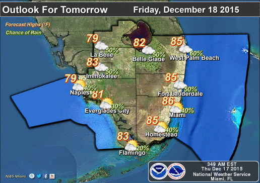
By Donna Thomas, SouthFloridaReporter.com Meteorologist, Dec. 18, 2015 – South Florida will have one more warm day on Friday before the much anticipated cold front arrives. First, we’ll have to get through another day of highs in the mid 80s and some late Friday afternoon and evening showers and storms. Temperatures will gradually drop late Friday, and Saturday morning will see lows in the 60s with a few lingering showers.
The day will feature sun and clouds, a building breeze (along with a high risk of dangerous rip currents), and highs in the refreshing mid 70s.
Sunday morning lows will be in the 60s, and another refreshing day of a cool breeze, sun and clouds, and highs in the upper 70s is on tap.
We’ll warm up a bit on Monday, reaching the 80 degree mark, and passing showers will return to the forecast. Those hit and miss showers will be around on Tuesday and Wednesday, and the warm weather will return. Tuesday’s highs will reach the low 80s, and we’ll be back in the mid 80s on Wednesday. And it doesn’t look like Santa will bring us another cold front.


