

Wednesday features some sun, lots of clouds, and plenty of showers and storms that will taper off during the evening. Look for a gusty breeze along the Gulf coast. Highs on Wednesday will be mostly in the upper 80s, with a few locations reaching the 90 degree mark.
Thursday will bring some sun, more clouds, and plenty of showers and storms to the mainland. Look for mostly sunny skies with some showers at times in the Keys. Thursday’s highs will be mostly in the upper 80s.
Independence Day will feature a bit of sun alternating with clouds, showers, and storms as tropical moisture affects South Florida. Heavy rain is possible. Right now, it looks like a wet evening, so check to make sure fireworks shows are still on before venturing out. Friday’s highs will be in the upper 80s.
Saturday will be another wet and cloudy day, with morning showers and afternoon storms as tropical moisture lingers. Saturday’s highs will be in the upper 80s.

Sunday’s forecast calls for some sun, more clouds, and plenty of showers and storms. Highs on Sunday will be in the upper 80s again.
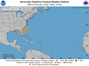 In the tropics, we’re watching the eastern Gulf, much of the Florida peninsula, and the Atlantic off the Georgia and Carolina coasts as a stalling front will lead to disturbed weather and possible tropical development. The National Hurricane Center still gives this feature a low chance of becoming a tropical or subtropical depression, but it will bring heavy rain — including to South Florida over the Fourth of July weekend.
Disclaimer
Artificial Intelligence Disclosure & Legal Disclaimer
AI Content Policy.
To provide our readers with timely and comprehensive coverage, South Florida Reporter uses artificial intelligence (AI) to assist in producing certain articles and visual content.
Articles: AI may be used to assist in research, structural drafting, or data analysis. All AI-assisted text is reviewed and edited by our team to ensure accuracy and adherence to our editorial standards.
Images: Any imagery generated or significantly altered by AI is clearly marked with a disclaimer or watermark to distinguish it from traditional photography or editorial illustrations.
General Disclaimer
The information contained in South Florida Reporter is for general information purposes only.
South Florida Reporter assumes no responsibility for errors or omissions in the contents of the Service. In no event shall South Florida Reporter be liable for any special, direct, indirect, consequential, or incidental damages or any damages whatsoever, whether in an action of contract, negligence or other tort, arising out of or in connection with the use of the Service or the contents of the Service.
The Company reserves the right to make additions, deletions, or modifications to the contents of the Service at any time without prior notice. The Company does not warrant that the Service is free of viruses or other harmful components.


")


")