A changing weather pattern could bring relief to the Midwest and Northeast from Canadian wildfire smoke, which has blanketed the region, but it also comes with new risks.
AccuWeather forecasts that rounds of thunderstorms on Monday afternoon and evening will improve air quality and aid firefighting efforts, although the strongest storms may also produce damaging winds, flash flooding, hail and isolated tornadoes.
Smoke Forecast Through Midweek
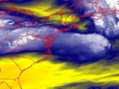
Millions of people will continue to experience changing air quality this week as Canadian wildfire smoke drifts across parts of the Midwest, Great Lakes and Ohio Valley. Shifting winds will cause smoke concentrations to fluctuate from day to day, with some locations experiencing a hazy sky while others see clearer air.

Some relief may be in sight later this week as storms are expected to move over where large wildfires continue to burn in Canada.
“The same storm that will bring risks for severe weather to the Midwest and eastern United States early this week will also bring rounds of rain and thunderstorms across western Ontario, potentially aiding in the firefighting efforts,” said AccuWeather Meteorologist Brandon Buckingham.
Enough rainfall later this week could help reduce the amount of low-level smoke across parts of the Midwest and Northeast. However, if rainfall is limited, western Ontario will remain vulnerable to new lightning-sparked wildfires, further straining firefighting efforts. If this were to occur, additional rounds of low-level smoke could continue to spread into the Midwest and Northeast.
Severe Storms Could Produce Tornadoes, Damaging Winds
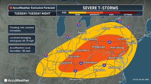
A round of severe thunderstorms is forecast to develop across parts of the Midwest and Great Lakes Monday afternoon through Monday night, with the greatest risk centered over portions of Iowa, Wisconsin, northern Illinois and Michigan’s Upper Peninsula.
The threat will shift into the Ohio Valley and Northeast on Tuesday and Tuesday night.
What AccuWeather Expert Meteorologists Are Tracking:
- Widespread damaging wind gusts of 60-75 mph, with an AccuWeather Local StormMax™ up to 90 mph
- Heavy rainfall that may trigger localized flash flooding
- Hail, and isolated tornadoes are possible
The strongest storms could lead to power outages, downed trees, travel delays, and hazardous conditions for outdoor activities.
Disclaimer
Artificial Intelligence Disclosure & Legal Disclaimer
AI Content Policy.
To provide our readers with timely and comprehensive coverage, South Florida Reporter uses artificial intelligence (AI) to assist in producing certain articles and visual content.
Articles: AI may be used to assist in research, structural drafting, or data analysis. All AI-assisted text is reviewed and edited by our team to ensure accuracy and adherence to our editorial standards.
Images: Any imagery generated or significantly altered by AI is clearly marked with a disclaimer or watermark to distinguish it from traditional photography or editorial illustrations.
General Disclaimer
The information contained in South Florida Reporter is for general information purposes only.
South Florida Reporter assumes no responsibility for errors or omissions in the contents of the Service. In no event shall South Florida Reporter be liable for any special, direct, indirect, consequential, or incidental damages or any damages whatsoever, whether in an action of contract, negligence or other tort, arising out of or in connection with the use of the Service or the contents of the Service.
The Company reserves the right to make additions, deletions, or modifications to the contents of the Service at any time without prior notice. The Company does not warrant that the Service is free of viruses or other harmful components.