

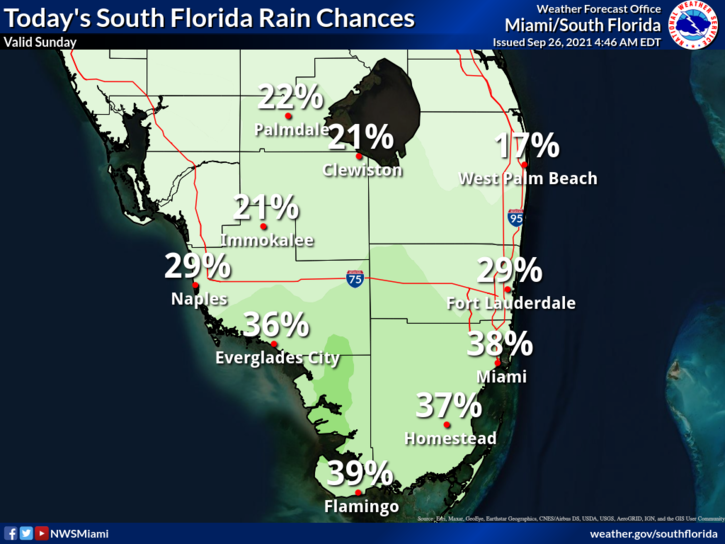
 Sunday features partly sunny skies with periods of showers in the east coast metro area, while the Gulf coast will enjoy lots of sun with just a few late afternoon showers.. A moderate risk of dangerous rip currents remains along the Palm Beach County coast. Highs on Sunday will be in the upper 80s in the east coast metro area and the low 90s along the Gulf coast.
LIVE RADAR 24/7 (Click Here Then Press Play)
Monday will bring drier air and sunny skies as we feel the effects of the first weak cold front of the season. Monday’s highs will be in the upper 80s in the east coast metro area and near 90 degrees along the Gulf coast.
Tuesday will feature more of the same — lots of sun with a few clouds and maybe a stray shower in spots. Tuesday’s highs will be in the upper 80s.

Wednesday will see a bit more moisture but plenty of sun. Look for a few showers and maybe a storm in the mid to late afternoon. Wednesday’s highs will be in the upper 80s.
Thursday’s forecast calls for good sun with some passing showers and maybe a storm. Highs on Thursday will be in the upper 80s again.
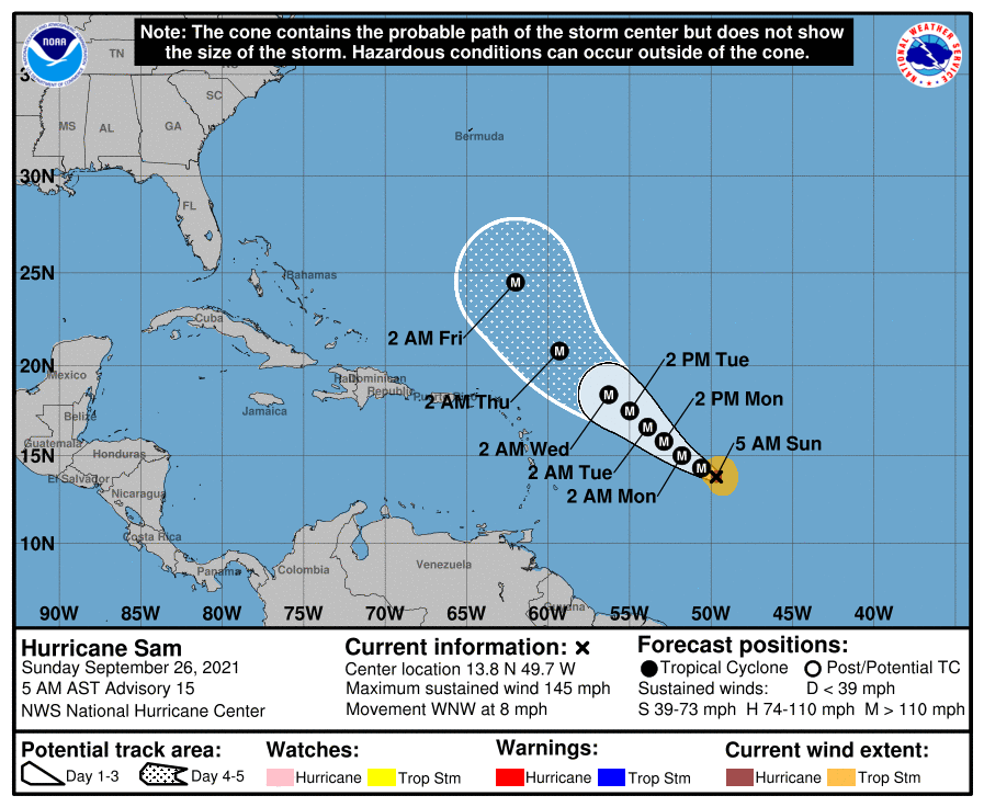 In the tropics, Hurricane Sam is now a powerful major hurricane. At 5 am, Sam was located near 13.8 North, 39.7 West, about 940 miles east-southeast of the northern Leeward Islands. Maximum sustained winds were 145 miles per hour, and Sam was moving west-northwest at 8 miles per hour. There are no watches and warnings at this time, and Sam is forecast to make a northwesterly and then northerly turn in the days ahead, keeping it far from the Bahamas and Florida.
 Elsewhere, the remnants of Peter have a low chance of becoming a depression again during the next five days as they move northeastward. A wave expected to emerge off the African coast on Monday has a medium chance of developing as it makes its way through the eastern Atlantic. And an area of low pressure is expected to form a few hundred miles west of that wave. That feature has a low chance of development during the week ahead.
Disclaimer
Artificial Intelligence Disclosure & Legal Disclaimer
AI Content Policy.
To provide our readers with timely and comprehensive coverage, South Florida Reporter uses artificial intelligence (AI) to assist in producing certain articles and visual content.
Articles: AI may be used to assist in research, structural drafting, or data analysis. All AI-assisted text is reviewed and edited by our team to ensure accuracy and adherence to our editorial standards.
Images: Any imagery generated or significantly altered by AI is clearly marked with a disclaimer or watermark to distinguish it from traditional photography or editorial illustrations.
General Disclaimer
The information contained in South Florida Reporter is for general information purposes only.
South Florida Reporter assumes no responsibility for errors or omissions in the contents of the Service. In no event shall South Florida Reporter be liable for any special, direct, indirect, consequential, or incidental damages or any damages whatsoever, whether in an action of contract, negligence or other tort, arising out of or in connection with the use of the Service or the contents of the Service.
The Company reserves the right to make additions, deletions, or modifications to the contents of the Service at any time without prior notice. The Company does not warrant that the Service is free of viruses or other harmful components.


