

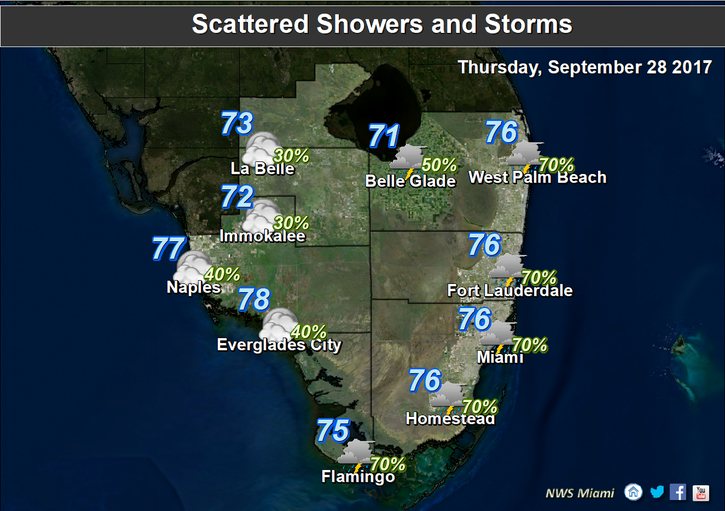
 Tropical rains are on the way to South Florida on Thursday and for the next several days, thanks to an area of disturbed weather to our south. Thursday features periods of passing showers and storms, and we could see heavy downpours in spots. An elevated risk of dangerous rip currents continues at the Atlantic beaches on Thursday and beyond. Highs on Thursday will be in the upper 80s.
 Look for clouds, storms, and showers on Friday, and localized flooding is possible. Friday’s highs will be in the upper 80s.
Our stormy pattern continues during the weekend, with periods of showers and storms, including downpours in spots and localized flooding. Highs on Saturday and Sunday will be in the upper 80s.
Monday will bring additional showers and storms. Monday’s highs will be in the upper 80s.

 We’re watching that disturbance to our south for its flooding potential. The National Hurricane Center gives it a medium chance of developing into a depression during the next 5 days as it moves slowly northward — but the threat will be heavy rain.
Elsewhere in the tropics, Tropical Storm Maria is beginning to pull out to sea at last. At 5 am Thursday, Maria was located near 36.8 North, 71.0 West, and was moving east-northeast at 8 miles per hour. Maximum sustained winds were 70 miles per hour. And Hurricane Lee was moving north at 9 miles per hour in the central Atlantic. At 5 am Thursday, Lee was located near 32.5 North, 57.2 West, and had maximum sustained winds of 110 miles per hour.
Disclaimer
Artificial Intelligence Disclosure & Legal Disclaimer
AI Content Policy.
To provide our readers with timely and comprehensive coverage, South Florida Reporter uses artificial intelligence (AI) to assist in producing certain articles and visual content.
Articles: AI may be used to assist in research, structural drafting, or data analysis. All AI-assisted text is reviewed and edited by our team to ensure accuracy and adherence to our editorial standards.
Images: Any imagery generated or significantly altered by AI is clearly marked with a disclaimer or watermark to distinguish it from traditional photography or editorial illustrations.
General Disclaimer
The information contained in South Florida Reporter is for general information purposes only.
South Florida Reporter assumes no responsibility for errors or omissions in the contents of the Service. In no event shall South Florida Reporter be liable for any special, direct, indirect, consequential, or incidental damages or any damages whatsoever, whether in an action of contract, negligence or other tort, arising out of or in connection with the use of the Service or the contents of the Service.
The Company reserves the right to make additions, deletions, or modifications to the contents of the Service at any time without prior notice. The Company does not warrant that the Service is free of viruses or other harmful components.


")


")