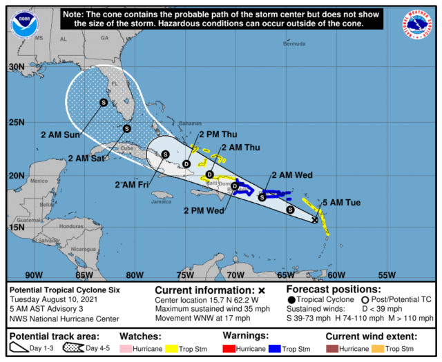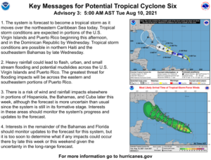
We’re watching the tropical Atlantic, where Potential Tropical Cyclone # 6 is expected to become Tropical Storm Fred on Tuesday. South Florida is in the 4-to-5 day “cone” for this system, and we could see impacts on Friday into Saturday.
Meanwhile, our weather on Tuesday features good sun and a few showers in the morning and early afternoon. Then look for more widespread showers and some storms in the mid to late afternoon, with the bulk of the activity along the Gulf Coast and in the interior. Highs on Tuesday will be in the low 90s.
LIVE RADAR 24/7 (Click Here Then Press Play)
Wednesday will be another humid August day with plenty of hot sun and periods of showers and storms in the afternoon. Wednesday’s highs will be in the low 90s.
Thursday will feature good sun and a few clouds in the morning, but showers and storms will dominate in the afternoon. Thursday’s highs will be in the low 90s again..
The forecast for Friday will depend on the track and strength of what’s now Potential TC # 6. For now, we’ll say Friday will be mostly cloudy with periods of showers and storms. Look for increasing showers and storms and periods of gusty winds during the night and in the early morning hours of Saturday. Friday’s highs will be near 90 degrees in the east coast metro area and in the low 90s along the Gulf coast.
Saturday’s forecast will again depend on the tropics. At this time, we’ll say to expect prolonged periods of showers and storms, with gusty winds and heavy rain. Flooding is possible in some locations. Highs on Saturday will be mostly in the upper 80s.

Potential TC # 6 is forecast to be near or over Puerto Rico and the U.S. Virgin Islands Tuesday night into Wednesday as a tropical storm. It is expected to move over Hispaniola on Wednesday and weaken to a depression, regaining tropical storm strength near Cuba or in the Florida Straits early Friday. South Florida could feel some effects of this system late Friday, with the closest approach likely to be early on Saturday. At this point, it’s too early to tell exactly what those impacts will be. We need to watch the situation carefully and be ready to take any necessary action on Thursday or during the day on Friday.


