

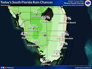
 The 4th of July features a sunny morning along the Gulf coast and a mix of sun and clouds in the east coast metro area. Some showers and storms will be around in the afternoon and early evening, especially in the western portions of South Florida. But most of the rain should be gone by the time fireworks shows are ready to start. A high risk of dangerous rip currents remains at the Atlantic beaches through Tuesday. Highs on Monday will be in the upper 80s right at the Atlantic coast and in the low 90s elsewhere in South Florida.
LIVE RADAR 24/7 (Click Here Then Press Play)
Tuesday will bring a mix of sun, clouds, and plenty of storms as tropical moisture moves in. Look for increasing storm chances as the day progresses. Tuesday’s highs will be in the upper 80s right at the Atlantic coast, near 90 degrees elsewhere in the east coast metro area, and in the low 90s along the Gulf coast.
Wednesday will feature plenty of tropical moisture, lots of showers and storms, and some sun at times. Wednesday’s highs will be in the upper 80s in the east coast metro area and near 90 degrees along the Gulf coast.

Thursday will start with a sunny morning and end with some afternoon storms in the east coast metro area. Tropical moisture lingers a bit along the Gulf coast, so look for a mix of sun, clouds, and storms. Thursday’s highs will be near 90 degrees.
Friday’s forecast calls for a summertime mix of sun, clouds, and periods of showers and storms. Highs on Friday will be in the low 90s.
The tropical Atlantic is quiet right now.
Disclaimer
Artificial Intelligence Disclosure & Legal Disclaimer
AI Content Policy.
To provide our readers with timely and comprehensive coverage, South Florida Reporter uses artificial intelligence (AI) to assist in producing certain articles and visual content.
Articles: AI may be used to assist in research, structural drafting, or data analysis. All AI-assisted text is reviewed and edited by our team to ensure accuracy and adherence to our editorial standards.
Images: Any imagery generated or significantly altered by AI is clearly marked with a disclaimer or watermark to distinguish it from traditional photography or editorial illustrations.
General Disclaimer
The information contained in South Florida Reporter is for general information purposes only.
South Florida Reporter assumes no responsibility for errors or omissions in the contents of the Service. In no event shall South Florida Reporter be liable for any special, direct, indirect, consequential, or incidental damages or any damages whatsoever, whether in an action of contract, negligence or other tort, arising out of or in connection with the use of the Service or the contents of the Service.
The Company reserves the right to make additions, deletions, or modifications to the contents of the Service at any time without prior notice. The Company does not warrant that the Service is free of viruses or other harmful components.


