

 Sunday features lots of sun in the morning, with periods of showers and storms in the afternoon. Look for the bulk of the activity to be in the east coast metro area. Highs on Sunday will be in the sticky low 90s, except for some readings in the upper 80s right along the Gulf coast.
LIVE RADAR 24/7 (Click Here Then Press Play)
Labor Day will bring a mix of sun and showers. Morning sun and afternoon showers and storms will be on tap in the east coast metro area, while the Gulf coast will see good sun alternating with periods of showers and storms. Monday’s highs will be in the humid low 90s.
Tuesday will feature a mix of sun and clouds during the first part of the day and periods of showers and storms in the mid to late afternoon. Tuesday’s highs will be near 90 degrees.

Wednesday will see a mix of sun and clouds alternating with periods of showers and a few storms. Wednesday’s highs will be in the low 90s.
Thursday’s forecast calls for a mix of sun, showers, and storms. Highs on Thursday will be in the low 90s in the east coast metro area and near 90 degrees along the Gulf coast.
 In the tropics, Hurricane Larry is bringing dangerous rip currents and rough surf to the Lesser Antilles. At 5 am, Larry was located near 18.8 North, 49.0 West, about 1350 miles southeast of Bermuda. Maximum sustained winds were 120 miles per hour, and Larry was moving northwest at 14 miles per hour. Swells from Larry will create a rip current risk in much of the western Atlantic this week.
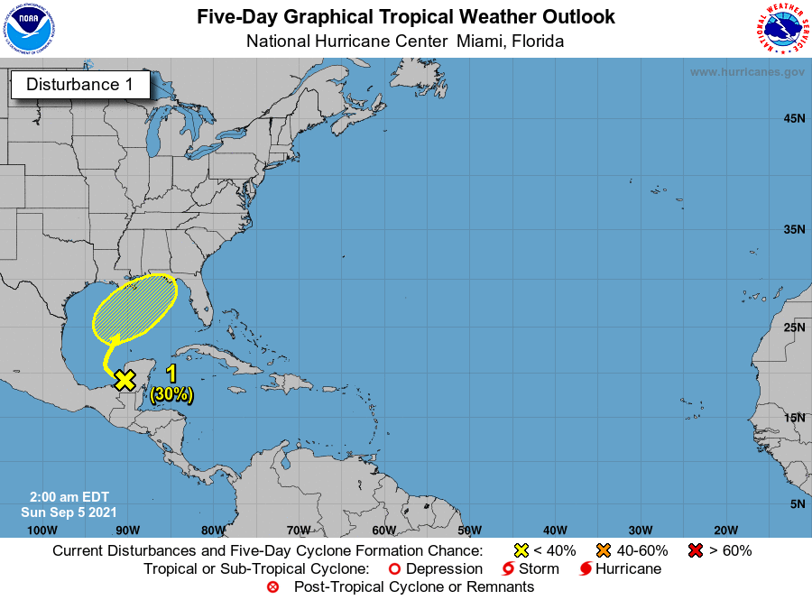 Elsewhere, the trough located over southern Mexico continues to bring rain to the region. While this system has virtually no chance of becoming a depression this weekend, some development is possible as it makes its way in the central Gulf of Mexico and in the direction of the northern Gulf coast.
Disclaimer
Artificial Intelligence Disclosure & Legal Disclaimer
AI Content Policy.
To provide our readers with timely and comprehensive coverage, South Florida Reporter uses artificial intelligence (AI) to assist in producing certain articles and visual content.
Articles: AI may be used to assist in research, structural drafting, or data analysis. All AI-assisted text is reviewed and edited by our team to ensure accuracy and adherence to our editorial standards.
Images: Any imagery generated or significantly altered by AI is clearly marked with a disclaimer or watermark to distinguish it from traditional photography or editorial illustrations.
General Disclaimer
The information contained in South Florida Reporter is for general information purposes only.
South Florida Reporter assumes no responsibility for errors or omissions in the contents of the Service. In no event shall South Florida Reporter be liable for any special, direct, indirect, consequential, or incidental damages or any damages whatsoever, whether in an action of contract, negligence or other tort, arising out of or in connection with the use of the Service or the contents of the Service.
The Company reserves the right to make additions, deletions, or modifications to the contents of the Service at any time without prior notice. The Company does not warrant that the Service is free of viruses or other harmful components.


