

 Thursday features lots of hot sun with some afternoon showers and storms, mostly along the Gulf Coast and in the interior. A moderate risk of dangerous rip currents is in place along the Palm Beach County coast. Highs on Thursday will be in the humid low 90s.
LIVE RADAR 24/7 (Click Here Then Press Play)
Friday will bring good sun, a few clouds at times, and the chance of a few afternoon showers with maybe a storm in spots. Friday’s highs will be in the upper 80s near the Atlantic coast and the low 90s elsewhere.
Saturday will feature sunny skies and the typical mid to late afternoon showers and storms. Saturday’s highs will be in the low 90s.

Sunday will see lots of sun, a few clouds at times, and some afternoon showers and storms. Sunday’s highs will be in the low 90s.
Monday’s forecast calls for good sun, clouds at times, and some showers and storms. Highs on Monday will be near 90 degrees in the east coast metro area and in the low 90s along the Gulf coast.
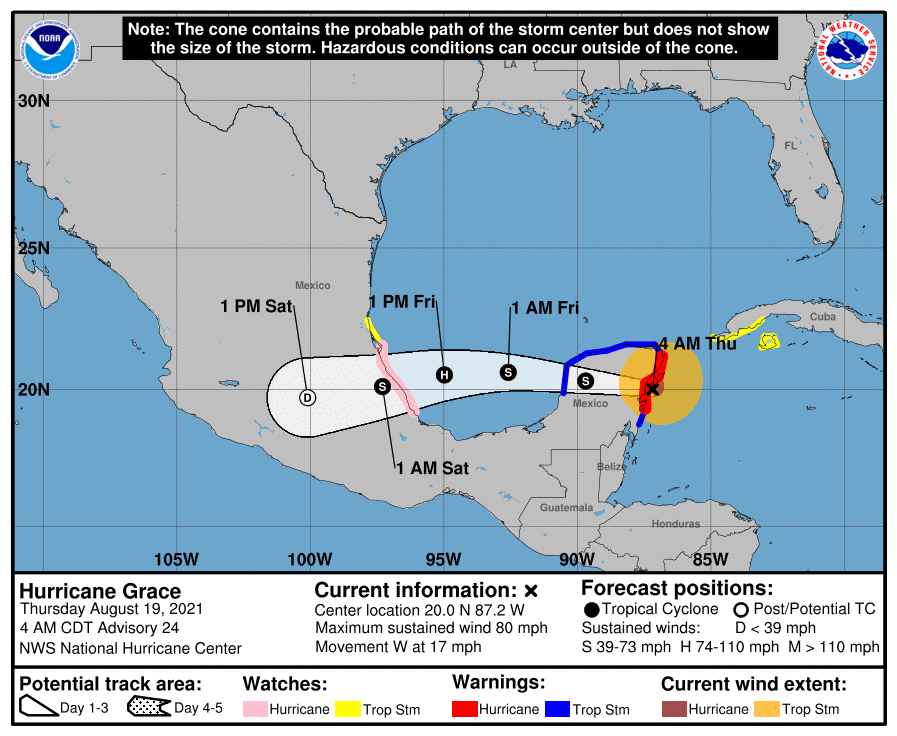 Hurricane Grace was moving just south of Cozumel early Thursday as it approached the Yucatan. At 5 am, Grace was located near 20.0 North, 87.2 West, about 25 miles southeast of Tulum. Maximum sustained winds were 80 miles per hour, and Grace was moving west at 17 miles per hour. Grace is expected to weaken over the Yucatan on Thursday but regain hurricane strength over the Bay of Campeche before final landfall along the Mexican coast on Friday.
 Tropical Storm Henri is expected to become a hurricane, and the Northeast will need to watch it closely. At 5 am Thursday, Henri was located near 29.5 North, 69.5 West, about 810 miles south of Nantucket, Massachusetts. Maximum sustained winds were 70 miles per hour, and Henri was moving west at 9 miles per hour. Most of coastal New England is in the 4-to-5-day “cone” as Henri is expected to make its closest approach late Sunday through Monday.
 Finally, the remnants of Fred are still bringing flooding rain and gusty winds to the mid-Atlantic states. At 5 am Thursday, what was left of Fred was centered about 125 miles west-southwest of Albany, New York. Maximum sustained winds were 25 miles per hour, and the system was moving east-northeast at 17 miles per hour. Flash flood watches are posted for parts of New York and central New England.
Disclaimer
Artificial Intelligence Disclosure & Legal Disclaimer
AI Content Policy.
To provide our readers with timely and comprehensive coverage, South Florida Reporter uses artificial intelligence (AI) to assist in producing certain articles and visual content.
Articles: AI may be used to assist in research, structural drafting, or data analysis. All AI-assisted text is reviewed and edited by our team to ensure accuracy and adherence to our editorial standards.
Images: Any imagery generated or significantly altered by AI is clearly marked with a disclaimer or watermark to distinguish it from traditional photography or editorial illustrations.
General Disclaimer
The information contained in South Florida Reporter is for general information purposes only.
South Florida Reporter assumes no responsibility for errors or omissions in the contents of the Service. In no event shall South Florida Reporter be liable for any special, direct, indirect, consequential, or incidental damages or any damages whatsoever, whether in an action of contract, negligence or other tort, arising out of or in connection with the use of the Service or the contents of the Service.
The Company reserves the right to make additions, deletions, or modifications to the contents of the Service at any time without prior notice. The Company does not warrant that the Service is free of viruses or other harmful components.


