

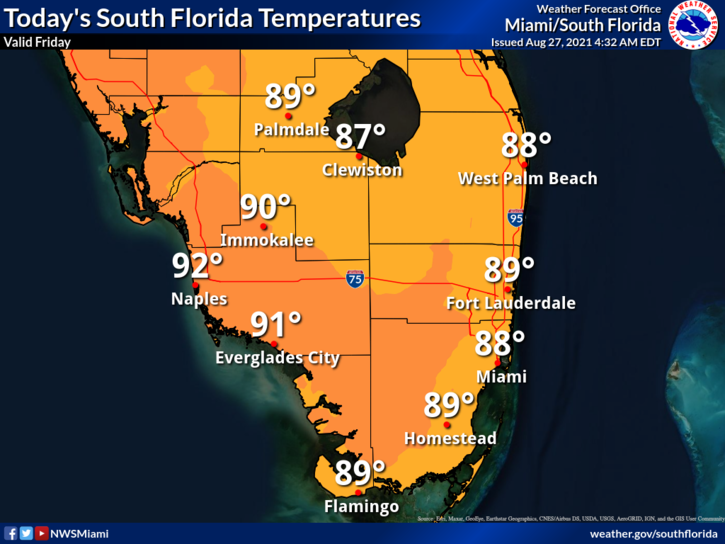
 Friday features a mix of sun and clouds with periods of summertime showers and storms. Look for mid to late afternoon activity along the Gulf coast, while showers and storms will blow through on a gusty ocean breeze throughout the day in the east coast metro area. A moderate risk of dangerous rip currents is in place at the Atlantic beaches. Highs on Friday will be mostly in the upper 80s in the east coast metro area and in the low 90s along the Gulf coast.
LIVE RADAR 24/7 (Click Here Then Press Play)
Saturday will bring sun, clouds, and mostly mid to late afternoon showers and storms. The gusty ocean breeze continues in the east coast metro area. Saturday’s highs will be near 90 degrees in the east coast metro area and in the low 90s along the Gulf coast.
Sunday’s weather will be a repeat of Saturday’s — with partly sunny skies in the morning and periods of showers and storms in the afternoon. Sunday’s highs will be mostly in the low 90s.

Monday will feature good sun and a few clouds alternating with passing showers and storms. Monday’s highs will be in the low 90s.
Tuesday’s forecast calls for mostly sunny skies and periods of showers and storms. Highs on Tuesday will be mostly in the low 90s.
 Tropical Storm Ida formed in the central Caribbean Thursday afternoon. At 5 am Friday, Ida was located near 20.0 North, 81.4 West, about 50 miles north-northwest of Grand Cayman. Maximum sustained winds were 45 miles per hour, and Ida was moving northwest at 15 miles per hour. A tropical storm warning is in effect for the Cayman Islands and western Cuba. A hurricane watch is in effect from Cameron, Louisiana to the Mississippi/Alabama border, including the New Orleans area. There’s a tropical storm watch from the Alabama border eastward to the Alabama/Florida border. Ida is expected to intensify in the Gulf of Mexico, possibly reaching category 3 status before reaching the northern Gulf coast. Besides damaging winds and flooding rain, Ida has the potential of bringing up to 7 feet of life-threatening storm surge to portions of the northern Gulf coast.
 In the central Atlantic, the disturbance well to the east-southeast of Bermuda has a medium chance of developing into a depression in the next couple of days, before conditions become more hostile. And the wave halfway between the Lesser Antilles and the Cape Verde Islands has a high chance of developing in the next few days as it moves generally northward into an area of unfavorable upper-level winds.
Disclaimer
Artificial Intelligence Disclosure & Legal Disclaimer
AI Content Policy.
To provide our readers with timely and comprehensive coverage, South Florida Reporter uses artificial intelligence (AI) to assist in producing certain articles and visual content.
Articles: AI may be used to assist in research, structural drafting, or data analysis. All AI-assisted text is reviewed and edited by our team to ensure accuracy and adherence to our editorial standards.
Images: Any imagery generated or significantly altered by AI is clearly marked with a disclaimer or watermark to distinguish it from traditional photography or editorial illustrations.
General Disclaimer
The information contained in South Florida Reporter is for general information purposes only.
South Florida Reporter assumes no responsibility for errors or omissions in the contents of the Service. In no event shall South Florida Reporter be liable for any special, direct, indirect, consequential, or incidental damages or any damages whatsoever, whether in an action of contract, negligence or other tort, arising out of or in connection with the use of the Service or the contents of the Service.
The Company reserves the right to make additions, deletions, or modifications to the contents of the Service at any time without prior notice. The Company does not warrant that the Service is free of viruses or other harmful components.


