

 Monday features periods of sun but passing showers and storms as well. A high risk of dangerous rip currents is in place at the Gulf beaches, and there’s an elevated rip current risk at the Atlantic beaches Highs on Monday will be near 90 degrees — but it will feel quite a bit hotter.
LIVE RADAR 24/7 (Click Here Then Press Play)
Tuesday will bring mostly sunny skies to the Gulf coast and a mix of sun and clouds to the east coast metro area. Look for showers and storms to develop during the mid to late afternoon. Tuesday’s highs will be near 90 degrees.
Wednesday will see breezy conditions and periods of showers and storms, along with sun at times. Wednesday’s highs will be near 90 degrees.

Thursday will be another breezy day with plenty of showers and storms as the moisture from Grace moves into South Florida. Heavy rain is possible in spots. Thursday’s highs will be in the upper 80s in the east coast metro area and near 90 degrees along the Gulf coast.
Friday will feature good sun and some showers and storms on the breeze. Highs on Friday will be near 90 degrees.
 In the tropics, Fred is back as a tropical storm. At 5 am Monday, Tropical Storm Fred was located near 27.9 North, 86.0 West, about 160 miles south of Panama City, Florida. Maximum sustained winds were 50 miles per hour, and Fred was moving north at 9 miles per hour. A tropical storm warning is in effect for most of the Florida panhandle. Flooding rain and dangerous storm surge are likely as Fred begins to affect the warning area on Monday.
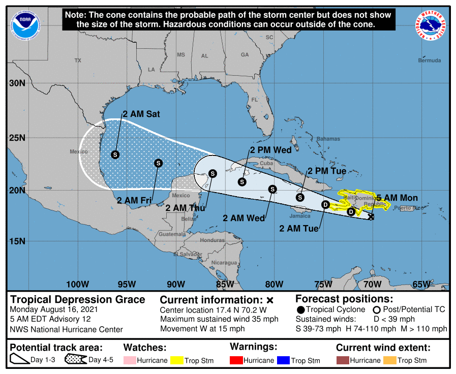 Grace is now a tropical depression, but it will create dangerous mudslides and flash flooding in Haiti on Monday. At 5 am, TD Grace was located near 17.4 North, 70.2 West, about 160 miles east-southeast of Port-au-Prince. Maximum sustained winds were 35 miles per hour, and Grace was moving west at 15 miles per hour. A tropical storm watch is in effect for the entire coast of Hispaniola. Grace is forecast to regain tropical storm strength on Tuesday and move into the Gulf of Mexico late Wednesday or early Thursday. It does not pose a threat to South Florida.
 Elsewhere in the very busy tropics, Tropical Depression # 8 has formed about 100 miles east of Bermuda. At 5 am Monday, TD # 8 was located near 32.4 North, 62.9 West, and was moving south-southwest at 5 miles per hour. Maximum sustained winds were 35 miles per hour. A tropical storm watch is in effect for Bermuda. TD # 8 is forecast to become a tropical storm (the next name on the list is Henri) and loop around Bermuda
Disclaimer
Artificial Intelligence Disclosure & Legal Disclaimer
AI Content Policy.
To provide our readers with timely and comprehensive coverage, South Florida Reporter uses artificial intelligence (AI) to assist in producing certain articles and visual content.
Articles: AI may be used to assist in research, structural drafting, or data analysis. All AI-assisted text is reviewed and edited by our team to ensure accuracy and adherence to our editorial standards.
Images: Any imagery generated or significantly altered by AI is clearly marked with a disclaimer or watermark to distinguish it from traditional photography or editorial illustrations.
General Disclaimer
The information contained in South Florida Reporter is for general information purposes only.
South Florida Reporter assumes no responsibility for errors or omissions in the contents of the Service. In no event shall South Florida Reporter be liable for any special, direct, indirect, consequential, or incidental damages or any damages whatsoever, whether in an action of contract, negligence or other tort, arising out of or in connection with the use of the Service or the contents of the Service.
The Company reserves the right to make additions, deletions, or modifications to the contents of the Service at any time without prior notice. The Company does not warrant that the Service is free of viruses or other harmful components.


