


South Florida will be seasonably hot this Labor Day weekend, but we’re watching as Hermine poses a major flooding threat along the mid-Atlantic coast.
Here in South Florida, Saturday includes sun and clouds, highs near 90 degrees, and just a stray afternoon storm in the east coast metro areas and a bit higher chance of late afternoon storms in the Naples and Marco Island areas. The risk of dangerous rip currents will be slowly easing along the Gulf coast beaches this weekend, even as the rip current risk increases along the Atlantic coast over the next few days.
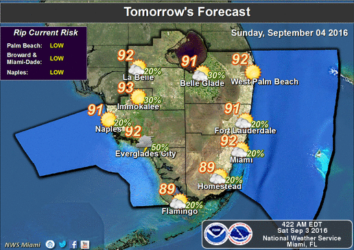 Sunday features sun and clouds, highs in the sticky low 90s, and a few quick afternoon storms throughout the area.
Some early east coast showers will start off Labor Day. Monday’s highs will be near 90 degrees, and a stray afternoon storm is possible in Miami-Dade and Broward, while the Gulf coast will see more widespread afternoon storms.
Tuesday and Wednesday will see sun and clouds, highs near 90 degrees, and just a storm or two for the east coast and more widespread afternoon storms along the Gulf coast.
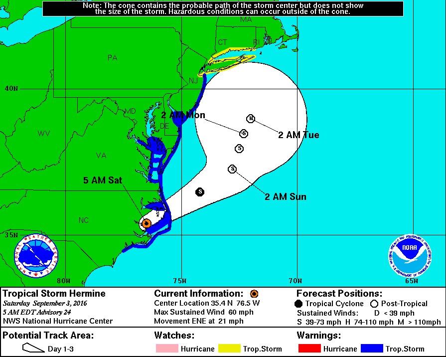 We’re watching Tropical Storm Hermine with growing concern as it moves off the North Carolina coast early Saturday.
At 5 am Saturday, Hermine was located near 35.4 North, 76.5 West, about 55 miles north of Cape Lookout, North Carolina. Hermine was moving east-northeast at 21 miles per hour, and top winds were 60 miles per hour.
Hermine is forecast to slow down over the warm Gulf stream waters, interact with an upper level trough, meander off the coast, and transform into a sub-tropical or post-tropical storm — but one with strong tropical storm force — or even hurricane force — winds.
Hermine will bring heavy rain and damaging winds to coastal areas from North Carolina into southern New England into midweek — but its greatest threat is storm surge flooding, enhanced at high tides. Many mid-Atlantic and northeast coastal areas can expect 2 to 4 feet of flooding — but the big concern right now is for Hampton Roads, Virginia, which could see 5 to 7 feet of flooding Saturday and Sunday — in an area that is already struggling to cope with sea level rise.
Other areas especially at risk from Hermine’s storm surge are the Jersey shore, parts of metro New York, and Bridgeport, Connecticut.
There’s better news elsewhere in the tropics. Gaston has weakened to a remnant low as it zips away from the Azores. And the wave in the central Atlantic has a low chance of developing over the next 5 days.


")


