

 South Florida will see more tropical rains associated with Tropical Depression # 9 on Tuesday. Showers and storms will blow through the region throughout the day and evening on Tuesday, and periods of heavy downpours will lead to localized flooding in spots. Highs will be in the mid to upper 80s. A high risk of rip currents continues at the Atlantic beaches on Tuesday, and the rip current risk will increase at Gulf beaches on Tuesday into Wednesday.
The showers and storms will linger on Wednesday, with heaviest activity over the Gulf coast. Wednesday’s highs will be in the mid to upper 80s.
 The rain will begin to taper off along the east coast and the Keys on Thursday, but showers and storms will linger over the Naples area one more day. Thursday’s highs will be in the low 90s in Miami-Dade, Broward, and the interior and in the upper 80s along the Gulf coast.
We’ll see passing showers and storms, some periods of sun, and highs mostly in the sticky low 90s (and higher readings in some locations) on Friday.

Saturday will feature our typical pattern of afternoon storms and highs in the muggy low 90s.
 Tropical Depression # 9 is expected to reach tropical storm strength on Tuesday. At 5 pm Monday, TD # 9 was located near 24.0 North, 84.8 West, and was moving west-northwest at 5 miles per hour. Top winds were 35 miles per hour. TD # 9 will eventually turn to the northeast and is forecast to make landfall along Florida’s northern Gulf coast on Thursday, cross the northern portion of the state, and emerge in the Atlantic.
 Elsewhere in the tropics, we have our hands full. Tropical Depression # 8 is on the verge of becoming a tropical storm and will bring heavy rain and gusty winds to the Outer Banks of North Carolina on Tuesday before going out to sea. A tropical storm warning is in effect for parts of the North Carolina coast.
Hurricane Gaston is slowly weakening and has turned to the north-northeast. It is forecast to weaken to a tropical storm by the time it approaches the Azores late in the week. A trough off the central Texas coast has a low chance of developing into a depression over the next 5 days.
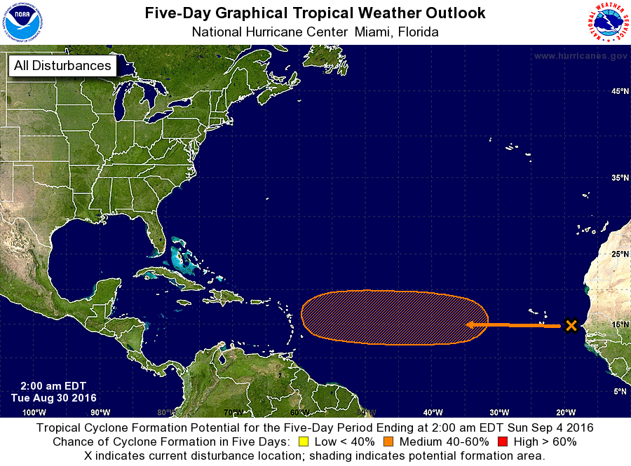 And one we’ll watch closely — a wave just emerging off the African coast has a medium chance of developing over the next 5 days as it approaches the Lesser Antilles.
Disclaimer
Artificial Intelligence Disclosure & Legal Disclaimer
AI Content Policy.
To provide our readers with timely and comprehensive coverage, South Florida Reporter uses artificial intelligence (AI) to assist in producing certain articles and visual content.
Articles: AI may be used to assist in research, structural drafting, or data analysis. All AI-assisted text is reviewed and edited by our team to ensure accuracy and adherence to our editorial standards.
Images: Any imagery generated or significantly altered by AI is clearly marked with a disclaimer or watermark to distinguish it from traditional photography or editorial illustrations.
General Disclaimer
The information contained in South Florida Reporter is for general information purposes only.
South Florida Reporter assumes no responsibility for errors or omissions in the contents of the Service. In no event shall South Florida Reporter be liable for any special, direct, indirect, consequential, or incidental damages or any damages whatsoever, whether in an action of contract, negligence or other tort, arising out of or in connection with the use of the Service or the contents of the Service.
The Company reserves the right to make additions, deletions, or modifications to the contents of the Service at any time without prior notice. The Company does not warrant that the Service is free of viruses or other harmful components.
")


")

