

 It’s all about Hurricane Matthew now as the possibility of impacts to South Florida have become much more likely. We’re now expected to see tropical storm conditions in Broward and Miami-Dade late Wednesday into Friday.
In the meantime, passing showers and storms will move throughout the region on Tuesday, with highs in the upper 80s, and similar conditions are in the forecast for most of the day on Wednesday.
You Can track Matthew via The Weather Channel HERE
 Winds will pick up late on Wednesday, and sustained winds greater than 39 miles per hour are likely in Miami-Dade and Broward on Thursday into Friday, with the core of Matthew expected to be in the northwestern Bahamas during that time.

Palm Beach County will likely see periods of hurricane force winds on Thursday into Friday.
While the Gulf coast and most of the Keys are not in the forecast “cone,” gusty winds and passing storms are likely as this very large hurricane approaches the east coast.
Conditions around the region will gradually improve late on Friday into Saturday as Matthew moves further north just off the U.S. east coast.
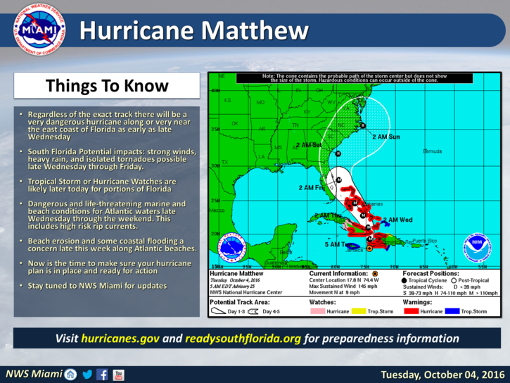
 Matthew remains a dangerous major hurricane. At 5 am Tuesday, it was located near 17.8 North, 74.4 West, or about 165 miles south of the eastern tip of Cuba.
Matthew had maximum sustained winds of 145 miles per hour and was moving north at 9 miles per hour. It continues to batter Haiti and drop 20 or more inches of rain on a nation that is especially prone to catastrophic mud slides and flooding. Matthew will then move through the Bahamas, and hurricane warnings are now in effect for all of the Bahamas.
Parts of South Florida can expect to see tropical storm warnings and hurricane watches, possibly later on Tuesday.
Now is the time to get prepared for tropical storm conditions, including power outages and damaging winds. Make sure you have the supplies you’ll need, and take in any outdoor items that could be picked up by strong winds.
Pay close attention to Matthew’s track and strength, and know if you would need to evacuate if Matthew’s track brings it even closer to South Florida.
You Can track Matthew via The Weather Channel HERE
Disclaimer
Artificial Intelligence Disclosure & Legal Disclaimer
AI Content Policy.
To provide our readers with timely and comprehensive coverage, South Florida Reporter uses artificial intelligence (AI) to assist in producing certain articles and visual content.
Articles: AI may be used to assist in research, structural drafting, or data analysis. All AI-assisted text is reviewed and edited by our team to ensure accuracy and adherence to our editorial standards.
Images: Any imagery generated or significantly altered by AI is clearly marked with a disclaimer or watermark to distinguish it from traditional photography or editorial illustrations.
General Disclaimer
The information contained in South Florida Reporter is for general information purposes only.
South Florida Reporter assumes no responsibility for errors or omissions in the contents of the Service. In no event shall South Florida Reporter be liable for any special, direct, indirect, consequential, or incidental damages or any damages whatsoever, whether in an action of contract, negligence or other tort, arising out of or in connection with the use of the Service or the contents of the Service.
The Company reserves the right to make additions, deletions, or modifications to the contents of the Service at any time without prior notice. The Company does not warrant that the Service is free of viruses or other harmful components.


")


 Cold Sweat Ice Cream Features Peppers So Hot You Must Sign A Waiver Before Eating It.")
