

 Tuesday features good sun with periods of showers and storms developing in the mid to late afternoon, especially in the east coast metro area. Highs on Tuesday will be in the low 90s in the east coast metro area and the upper 80s along the Gulf coast.
LIVE RADAR 24/7 (Click Here Then Press Play)
Wednesday will bring plenty of hot sun early in the day and some showers and a storm or two during the mid to late afternoon. Wednesday’s highs will be in the low to mid-90s in the east coast metro area and near 90 degrees along the Gulf coast.
Thursday will feature mostly sunny skies alternating with passing showers and storms along the Gulf coast, while the east coast metro area will see good sun and mostly afternoon showers and storms. Thursday’s highs will be in the low 90s in the east coast metro area and the upper 80s along the Gulf coast.

Friday will start with mostly sunny skies, and periods of showers and storms will pop up in the mid to late afternoon. Friday’s highs will be in the low 90s in the east coast metro area and the upper 80s along the Gulf coast.
Saturday’s forecast calls for a mix of sun, showers, and storms. Highs on Saturday will be near 90 degrees.
 Ida is now a tropical depression, but it continues to bring heavy rain to portions of the South. At 5 am, Tuesday, Tropical Depression Ida was located about 185 miles southwest of Nashville, Tennessee. Maximum sustained winds were 30 miles per hour, and Ida was moving northeast at 12 miles per hour.
 Tropical Storm Kate formed on Monday from what had been Tropical Depression # 10. At 5 am Tuesday, TS Kate was located near 23.0 North, 50.9 West, about 810 miles east-northeast of the Leeward Islands. Maximum sustained winds were 40 miles per hour, and Kate was moving north at 5 miles per hour. Kate is not well organized and is expected to remain in the open waters of the Atlantic.
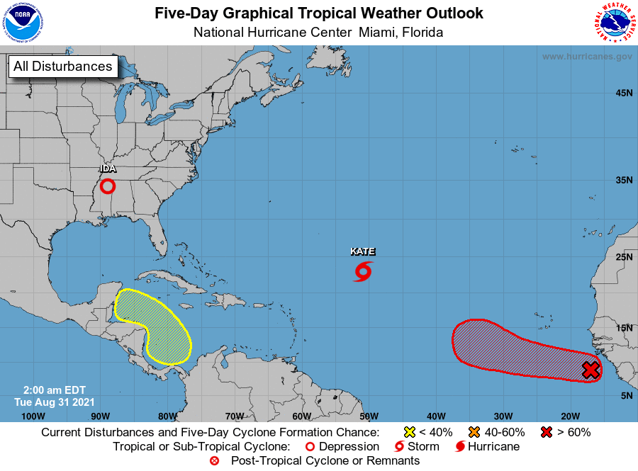 Elsewhere, a strong wave just off the African coast has a high chance of becoming a depression during the next day or so.. And a broad area of low pressure is expected to develop in the southern Caribbean later this week. This feature has a low chance of becoming a depression during the next five days as it approaches the coast of Central America.
Disclaimer
Artificial Intelligence Disclosure & Legal Disclaimer
AI Content Policy.
To provide our readers with timely and comprehensive coverage, South Florida Reporter uses artificial intelligence (AI) to assist in producing certain articles and visual content.
Articles: AI may be used to assist in research, structural drafting, or data analysis. All AI-assisted text is reviewed and edited by our team to ensure accuracy and adherence to our editorial standards.
Images: Any imagery generated or significantly altered by AI is clearly marked with a disclaimer or watermark to distinguish it from traditional photography or editorial illustrations.
General Disclaimer
The information contained in South Florida Reporter is for general information purposes only.
South Florida Reporter assumes no responsibility for errors or omissions in the contents of the Service. In no event shall South Florida Reporter be liable for any special, direct, indirect, consequential, or incidental damages or any damages whatsoever, whether in an action of contract, negligence or other tort, arising out of or in connection with the use of the Service or the contents of the Service.
The Company reserves the right to make additions, deletions, or modifications to the contents of the Service at any time without prior notice. The Company does not warrant that the Service is free of viruses or other harmful components.


