

 Tuesday features periods of sun in the morning but lots of showers, especially from the late morning onward. Some storms will develop in the mid to late afternoon. A moderate risk of dangerous rip currents remains along the Palm Beach County coast. Highs on Tuesday will be mostly in the upper 80s in the east coast metro area and near 90 degrees along the Gulf coast.
LIVE RADAR 24/7 (Click Here Then Press Play)
Wednesday will bring mostly sunny skies during much of the morning, with periods of showers in the afternoon. Some storms will develop in the mid to late afternoon. Wednesday’s highs will be in the upper 80s near the coasts and in the low 90s elsewhere.
Thursday will feature good sun in the morning and showers and storms during the mid to late afternoon. Thursday’s highs will be near 90 degrees in the east coast metro area and in the low 90s along the Gulf coast.

Friday will start with a mostly sunny morning, followed by periods of showers and storms in the afternoon. Friday’s highs will be mostly in the low 90s.
Saturday’s forecast calls for a mix of sun, showers, and some storms in spots. Highs on Saturday will be in the low 90s.
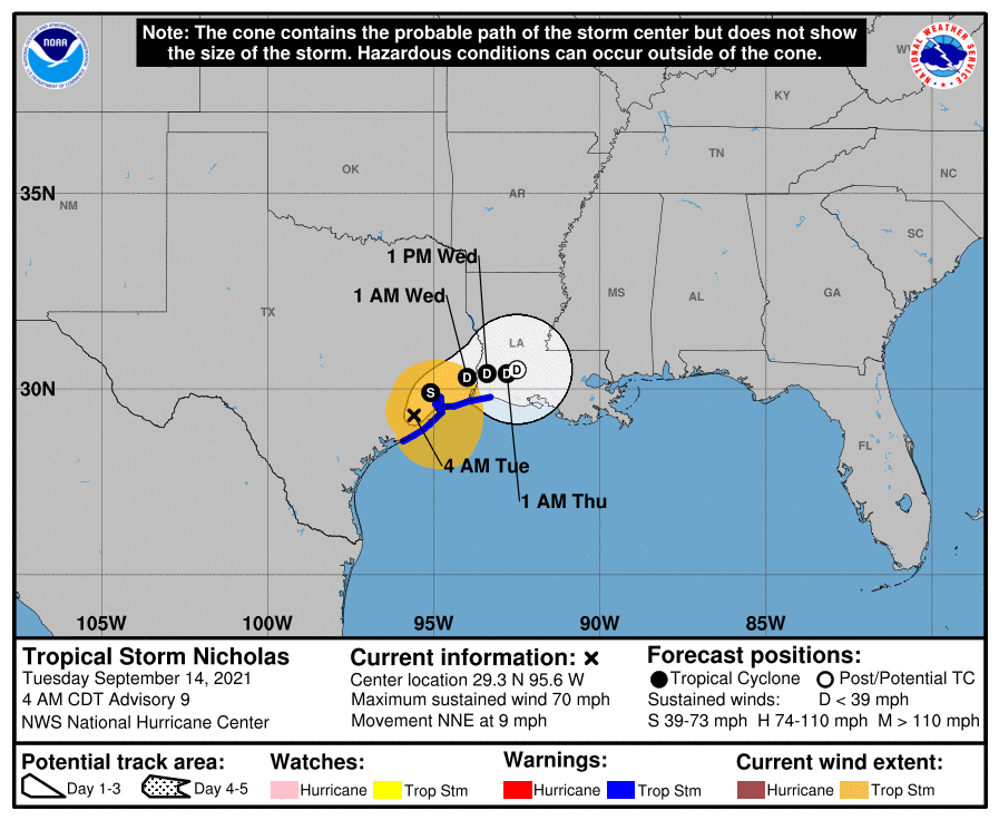 In the tropics, Nicholas reached hurricane strength just before landfall in Texas overnight. Having weakened to a tropical storm at 5 am, Nicholas was then located near 29.3 North, 95.6 West, about 30 miles south-southwest of Houston, Texas. Maximum sustained winds were 70 miles per hour, and Nicholas was moving north-northeast at 9 miles per hour.. A tropical storm warning is in effect from Matagorda, Texas to Cameron, Louisiana. Nicholas will bring damaging winds and flooding rains to portions of Texas and Louisiana today into Wednesday.
 Elsewhere, the low a couple of hundred miles east of the Bahamas has a medium chance of developing into a depression during the next five days as it moves to the northwest and then northeast. A wave in the far eastern Atlantic has a high chance of becoming a depression during the next five days.
Disclaimer
Artificial Intelligence Disclosure & Legal Disclaimer
AI Content Policy.
To provide our readers with timely and comprehensive coverage, South Florida Reporter uses artificial intelligence (AI) to assist in producing certain articles and visual content.
Articles: AI may be used to assist in research, structural drafting, or data analysis. All AI-assisted text is reviewed and edited by our team to ensure accuracy and adherence to our editorial standards.
Images: Any imagery generated or significantly altered by AI is clearly marked with a disclaimer or watermark to distinguish it from traditional photography or editorial illustrations.
General Disclaimer
The information contained in South Florida Reporter is for general information purposes only.
South Florida Reporter assumes no responsibility for errors or omissions in the contents of the Service. In no event shall South Florida Reporter be liable for any special, direct, indirect, consequential, or incidental damages or any damages whatsoever, whether in an action of contract, negligence or other tort, arising out of or in connection with the use of the Service or the contents of the Service.
The Company reserves the right to make additions, deletions, or modifications to the contents of the Service at any time without prior notice. The Company does not warrant that the Service is free of viruses or other harmful components.


