

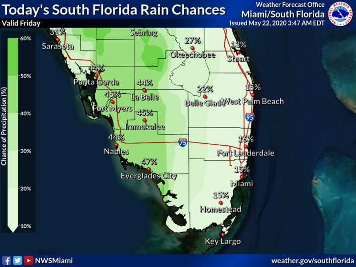
 Friday features lots of hot sun and a few quick east coast showers to start. Then we’ll see afternoon showers and storms, especially along the Gulf coast and in the interior. A high risk of dangerous rip currents remains along the Palm Beach County coast, and there’s a moderate rip current risk off the Miami-Dade and Broward coasts. Highs on Friday will be in the upper 80s in the east coast metro area, while the Gulf coast will see highs in the very humid low 90s.
LIVE RADAR 24/7 (Click Here Then Press Play)
Saturday will bring a mix of sun, clouds, and passing showers and storms. Saturday’s highs will be in upper 80s.
Sunday will start with good sun and some clouds. Then showers and storms will develop around our area during the afternoon. Sunday’s highs will be in the upper 80s to low 90s.

Memorial Day will feature hot sun, clouds at times, and periods of showers and storms. Look for a building breeze along the east coast. Monday’s highs will be mostly in the upper 80s.
Tuesday’s forecast calls for another summerlike day with plenty of sun and periods of clouds, showers, and storms. Highs on Tuesday will be in the mid to upper 80s.
Disclaimer
Artificial Intelligence Disclosure & Legal Disclaimer
AI Content Policy.
To provide our readers with timely and comprehensive coverage, South Florida Reporter uses artificial intelligence (AI) to assist in producing certain articles and visual content.
Articles: AI may be used to assist in research, structural drafting, or data analysis. All AI-assisted text is reviewed and edited by our team to ensure accuracy and adherence to our editorial standards.
Images: Any imagery generated or significantly altered by AI is clearly marked with a disclaimer or watermark to distinguish it from traditional photography or editorial illustrations.
General Disclaimer
The information contained in South Florida Reporter is for general information purposes only.
South Florida Reporter assumes no responsibility for errors or omissions in the contents of the Service. In no event shall South Florida Reporter be liable for any special, direct, indirect, consequential, or incidental damages or any damages whatsoever, whether in an action of contract, negligence or other tort, arising out of or in connection with the use of the Service or the contents of the Service.
The Company reserves the right to make additions, deletions, or modifications to the contents of the Service at any time without prior notice. The Company does not warrant that the Service is free of viruses or other harmful components.


