

South Florida is wondering what happened to spring in the wake of a strong cold front. Tuesday morning will feel more like January, with lows ranging from the upper 40s well inland to the upper 50s right at the coast. Afternoon temperatures will be in the mid 70s, even with sun and a breeze off the ocean.
 On a typical day, we would experience the highest temperatures of the day during the mid to late afternoon with heating from the sun. On Monday however, we had our warmest temperatures of the day during the early morning hours before a cold fornt came through around daybreak and brought in a much cooler airmass. Temperatures fell or held fairly steady during the rest of the day across the region.
This sometimes is referred to as a “midnight high”, though the high temperature may not actually occur at midnight.
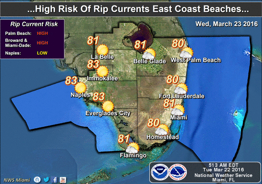 Wednesday will begin a warming trend, with highs in the upper 70s, sun and clouds, maybe a quick shower, and an increasing risk of dangerous rip currents at the Atlantic beaches.

Highs will be back in the low 80s on Thursday and Friday, and we can’t rule out a passing shower in spots.
[vc_message message_box_style=”3d” message_box_color=”turquoise”]By Donna Thomas, SouthFloridaReporter.com Meteorologist, Mar. 22, 2016
[/vc_message]Disclaimer
Artificial Intelligence Disclosure & Legal Disclaimer
AI Content Policy.
To provide our readers with timely and comprehensive coverage, South Florida Reporter uses artificial intelligence (AI) to assist in producing certain articles and visual content.
Articles: AI may be used to assist in research, structural drafting, or data analysis. All AI-assisted text is reviewed and edited by our team to ensure accuracy and adherence to our editorial standards.
Images: Any imagery generated or significantly altered by AI is clearly marked with a disclaimer or watermark to distinguish it from traditional photography or editorial illustrations.
General Disclaimer
The information contained in South Florida Reporter is for general information purposes only.
South Florida Reporter assumes no responsibility for errors or omissions in the contents of the Service. In no event shall South Florida Reporter be liable for any special, direct, indirect, consequential, or incidental damages or any damages whatsoever, whether in an action of contract, negligence or other tort, arising out of or in connection with the use of the Service or the contents of the Service.
The Company reserves the right to make additions, deletions, or modifications to the contents of the Service at any time without prior notice. The Company does not warrant that the Service is free of viruses or other harmful components.


")
")


