By Donna Thomas, SouthFloridaReporter.com Meteorologist, Sept. 30, 2015 –
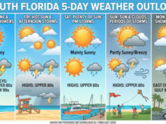
South Florida will have plenty of weather to watch on Wednesday, with another day of afternoon storms, coastal flooding, and a strengthening Joaquin threatening the Bahamas. The last morning of September features some patchy fog in spots, and the day will see highs near 90 degrees giving way to afternoon storms. While the storms may not be as widespread as on Tuesday, some areas will see heavy downpours and possible street flooding. Our coastal flood advisory is still in effect, with high tides on Wednesday coming shortly before 11 am and around 11 pm, and some street closures are likely. Thursday will bring some scattered afternoon storms, along with highs near 90 degrees, and expect some coastal flooding yet again. Friday will see clouds and a few showers and storms on the breeze, with highs in the upper 80s. The weekend will feel like fall, with plenty of sun, much lower humidity, and highs in the comfortable mid to upper 80s.
 The big story in the tropics is Tropical Storm Joaquin, expected to reach hurricane strength on Wednesday. It threatens parts of the Bahamas, and a hurricane warning is in effect for the central Bahamas and a hurricane watch has been issued for the northwestern Bahamas. Everyone there should be preparing for possible hurricane conditions. At 5 am Wednesday, Joaquin was located near 25.4 North, 72.5 West, and was moving west-southwest at 5 miles per hour. Maximum sustained winds were 70 miles per hour. Joaquin will move generally westward until sometime on Thursday, when it will turn northward as it interacts with a jet stream dip. While the computer models are in agreement that the turn will occur well east of South Florida, Joaquin’s track beyond that point is not certain, and watches and warnings may be necessary for parts of the U.S. coast from North Carolina northward late in the week. We’ll watch the track and intensity of Joaquin closely.
Disclaimer
Artificial Intelligence Disclosure & Legal Disclaimer
AI Content Policy.
To provide our readers with timely and comprehensive coverage, South Florida Reporter uses artificial intelligence (AI) to assist in producing certain articles and visual content.
Articles: AI may be used to assist in research, structural drafting, or data analysis. All AI-assisted text is reviewed and edited by our team to ensure accuracy and adherence to our editorial standards.
Images: Any imagery generated or significantly altered by AI is clearly marked with a disclaimer or watermark to distinguish it from traditional photography or editorial illustrations.
General Disclaimer
The information contained in South Florida Reporter is for general information purposes only.
South Florida Reporter assumes no responsibility for errors or omissions in the contents of the Service. In no event shall South Florida Reporter be liable for any special, direct, indirect, consequential, or incidental damages or any damages whatsoever, whether in an action of contract, negligence or other tort, arising out of or in connection with the use of the Service or the contents of the Service.
The Company reserves the right to make additions, deletions, or modifications to the contents of the Service at any time without prior notice. The Company does not warrant that the Service is free of viruses or other harmful components.


