

 We’re closely watching Tropical Storm Laura as it makes its way through the Greater Antilles this weekend. Just how close Laura comes to South Florida will make all the difference in our weather on Monday and Tuesday.
LIVE RADAR 24/7 (Click Here Then Press Play)
 Here at home, Saturday features lots of clouds along the Gulf coast and mostly sunny skies in the morning in the east coast metro area. Then showers and storms will develop in the afternoon, especially along the Gulf coast and in the interior. A moderate risk of rip currents is in place at the Atlantic beaches this weekend. Highs on Saturday will be in the steamy low 90s.

Sunday will start with a mix of sun and clouds, and showers and storms will pop up by the middle of the afternoon. Sunday’s highs will be in the low 90s in the east coast metro area and the mid 90s along the Gulf coast and in the interior.
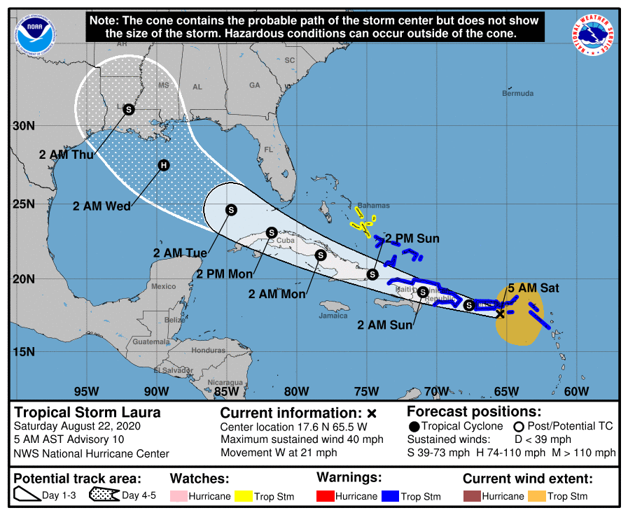
Monday will see Tropical Storm Laura’s closest approach to South Florida. On the present track, TS Laura could bring tropical conditions to the Lower and Middle Keys. Periods of tropical storm force winds and heavy rain are possible along the Gulf coast, while the east coast metro area is likely to see windy conditions and periods of heavy rain. Monday’s highs will be near 90 degrees.
Tuesday will be a transition day for South Florida, with gusty winds and periods of rain as begins to pull away in the morning hours. Winds will taper off and skies will clear as the day progresses. Tuesday’s highs will be in the low 90s.
Wednesday’s forecast calls for a mix of sun, clouds, showers, and storms. Highs on Wednesday will be in the low 90s.
The big story in the tropics remains Tropical Storm Laura, which moved over the Virgin Islands overnight. At 5 am Saturday, Laura was located near 17.6 North, 65.5 West, about 70 miles southeast of San Juan, Puerto Rico. Maximum sustained winds were 45 miles per hour, and Laura was moving west at 21 miles per hour. Laura will move over or very close to Puerto Rico and Hispaniola this weekend and much of Cuba on Sunday and Monday. Laura is quite disorganized early on Saturday, and its track is likely to limit strengthening. But there remains the serious threat of mudslides in the islands due to heavy rains from Laura. There are currently no watches or warnings for Florida, but there could be significant impacts from Laura in portions of the Keys, and limited evacuations have begun there Laura is expected to reach hurricane strength briefly in the Gulf of Mexico before making landfall along the northern Gulf coast on Wednesday.
 Elsewhere, what was Tropical Depression # 14 is now Tropical Storm Marco. At 5 am Saturday, Marco was located near 19.6 North, 85.4 West, about 115 miles east-southeast of Cozumel, Mexico. Maximum sustained winds were 45 miles per hour, and Marco was moving north-northwest at 12 miles per hour. Marco is forecast to move over or near portions of the Yucatan, enter the Gulf of Mexico, and make landfall as a tropical storm along the Texas or Louisiana coast late on Tuesday. Possible interactions between Marco and Laura could affect the track and strength of each system while in the Gulf. That’s a scenario we rarely see in the tropical Atlantic.
 As if that’s not enough, there’s also a tropical wave in the eastern Atlantic that has a low chance of developing before conditions become less favorable next week.
Disclaimer
Artificial Intelligence Disclosure & Legal Disclaimer
AI Content Policy.
To provide our readers with timely and comprehensive coverage, South Florida Reporter uses artificial intelligence (AI) to assist in producing certain articles and visual content.
Articles: AI may be used to assist in research, structural drafting, or data analysis. All AI-assisted text is reviewed and edited by our team to ensure accuracy and adherence to our editorial standards.
Images: Any imagery generated or significantly altered by AI is clearly marked with a disclaimer or watermark to distinguish it from traditional photography or editorial illustrations.
General Disclaimer
The information contained in South Florida Reporter is for general information purposes only.
South Florida Reporter assumes no responsibility for errors or omissions in the contents of the Service. In no event shall South Florida Reporter be liable for any special, direct, indirect, consequential, or incidental damages or any damages whatsoever, whether in an action of contract, negligence or other tort, arising out of or in connection with the use of the Service or the contents of the Service.
The Company reserves the right to make additions, deletions, or modifications to the contents of the Service at any time without prior notice. The Company does not warrant that the Service is free of viruses or other harmful components.


