Home Accuweather.com Super El Niño Threat Reshapes U.S. Seasonal Outlook and Suppresses Atlantic Hurricane...

Super El Niño Threat Reshapes U.S. Seasonal Outlook and Suppresses Atlantic Hurricane Activity

“It really does not matter whether this is a record or very strong El Niño. It is about the impacts, and the impacts will not change either way,” said AccuWeather lead long-range meteorologist Paul Pastelok. “We are seeing a strong impact in both the Atlantic, and Pacific basins, with extreme wind shear limiting Atlantic storm development, while the Pacific basin remains quite active, as we forecast back in the spring.”

Confidence in a Super El Niño is Near 100% Certainty

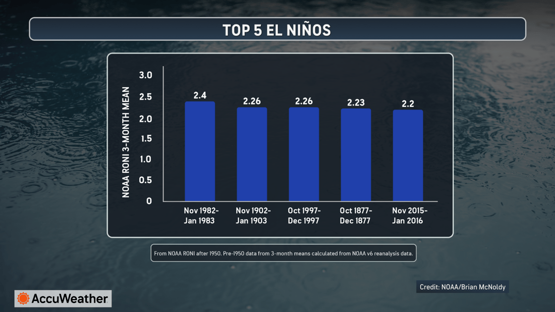
AccuWeather experts are near certain the conditions in the measured region of the Pacific Ocean will meet the threshold for Super El Niño for the first time since 2015. The measured water temperatures could also become the warmest since 1982-1983, when water temperatures rose on average 2.4°C above the historic average, which is the strongest recorded El Niño on record going back to 1950.

El Nino History Chart

El Niño’s impact goes well beyond just tropical activity; it can have a lasting impact on the U.S. throughout the upcoming fall and winter seasons.

Faith Based Events
  • More active southern storm track increasing the potential for flooding from the Southwest to the Southeast
  • Above-average temperatures favored across much of the northern tier of the United States
  • Drought improvement expected across parts of the southern U.S. later in the season as rainfall becomes more frequent
  • The Midwest can be drier at times during the winter resulting in less snow
  • The lack of cold periods in early winter could mean more rain or mixed events for the Northeast and mid-Atlantic

“When you have a strong El Niño, it changes the weather pattern across much of the country. Some areas become much wetter; others stay warmer than the historical average, and those shifts can have a big impact on flooding, drought, tropical activity, and even early-season snowfall,” Pastelok said in the 2026 AccuWeather Fall Forecast.

El Niño Continues to Strengthen Across the Tropical Pacific

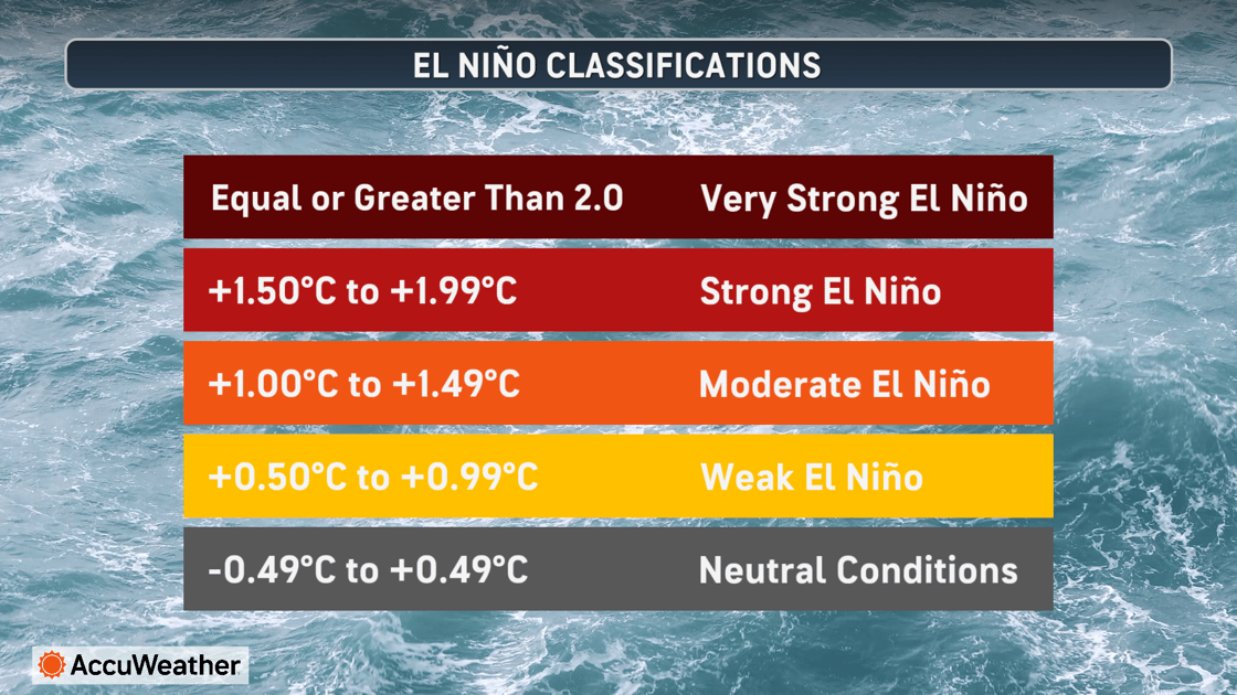
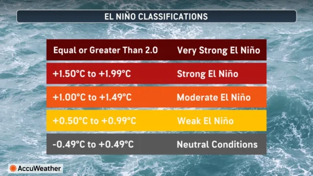
Ocean temperatures and atmospheric patterns display a well-established El Niño signal. From mid-July to mid-August, sea-surface temperatures in the measured region have averaged 2.0°C above the historic average.

The Relative Oceanic Niño Index (RONI) measures the average sea-surface temperature over overlapping three-month periods, for example: December–January–February, then January–February–March, then February–March–April.

From May-July, those temperatures averaged 1.0°C above the historic average, their warmest (with relation to the historical average temperature) over that measured period since 2015, when the last Super El Niño occurred. This pattern is expected to intensify into fall and winter.

El Nino Intensity Chart FIXED

Hurricane Forecast Update

Fueled by the increasingly strong El Niño conditions, AccuWeather now forecasts 8-11 named storms, 3-4 hurricanes and 1-2 major hurricanes during the 2026 Atlantic hurricane season.

Most likely outcome:

  • Named Storms: 9 (previous July updated forecast called for 11)
  • Hurricanes: 3 (previous July updated forecast called for 5)
  • Major Hurricanes: 1 (previous July updated forecast called for 2)
  • Direct U.S. Impacts: 4 (same as previous July updated forecast)

“We expect more frequent episodes of disruptive wind shear that can make it difficult for tropical systems to develop and strengthen,” said AccuWeather Lead Hurricane Expert Alex DaSilva. “That gives us greater confidence in lowering the total number of named storms, but it does not eliminate the risk of a damaging hurricane strike in the United States.”

AccuWeather expert meteorologists initially forecast 11-16 named storms in March and lowered that range to 8-14 in July.

Despite the lower seasonal forecast, the expected number of direct U.S. impacts remains unchanged at three to five, with four considered the most likely number.

image-Aug-19-2026-02-09-32-8660-PM

Disclaimer

Artificial Intelligence Disclosure & Legal Disclaimer

AI Content Policy.

To provide our readers with timely and comprehensive coverage, South Florida Reporter uses artificial intelligence (AI) to assist in producing certain articles and visual content.

Articles: AI may be used to assist in research, structural drafting, or data analysis. All AI-assisted text is reviewed and edited by our team to ensure accuracy and adherence to our editorial standards.

Images: Any imagery generated or significantly altered by AI is clearly marked with a disclaimer or watermark to distinguish it from traditional photography or editorial illustrations.

General Disclaimer

The information contained in South Florida Reporter is for general information purposes only.

South Florida Reporter assumes no responsibility for errors or omissions in the contents of the Service. In no event shall South Florida Reporter be liable for any special, direct, indirect, consequential, or incidental damages or any damages whatsoever, whether in an action of contract, negligence or other tort, arising out of or in connection with the use of the Service or the contents of the Service.

The Company reserves the right to make additions, deletions, or modifications to the contents of the Service at any time without prior notice. The Company does not warrant that the Service is free of viruses or other harmful components.