Home Accuweather.com Rough Seas and Tropical Threats Loom Over Florida’s Atlantic Coast

Rough Seas and Tropical Threats Loom Over Florida’s Atlantic Coast

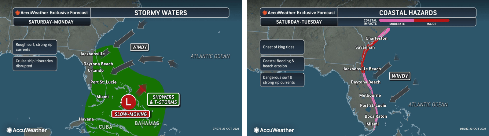
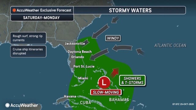
Florida’s East Coast is already dealing with coastal flooding, gusty winds and dangerous surf, and a new area of potential tropical development could prolong or worsen those conditions early next week.

Higher tides associated with the Hunter’s Moon overnight Sunday into early Monday, combined with persistent onshore winds, could further aggravate coastal flooding as the Atlantic remains active late into October.

“A storm doesn’t need to become a hurricane to cause significant problems along the coast. Even a weak or poorly organized system can bring persistent onshore winds, dangerous surf and coastal flooding. With Florida’s East Coast already dealing with repeated rounds of rough weather, another system could prolong those impacts and worsen beach erosion. It’s the potential impacts, not the storm’s classification, that people should be paying attention to,” said AccuWeather lead hurricane expert Alex DaSilva.

page-2-Oct-23-2026-09-11-10-7376-AM

What AccuWeather Expert Meteorologists Are Tracking

Faith Based Events
  • October 26-30: A low-pressure system moving northward from the Caribbean has a low chance of tropical development off Florida’s East Coast
  • Florida: Regardless of if development occurs, coastal flooding, dangerous surf and beach erosion will likely continue along the Atlantic coastline next week due to strong onshore winds
  • Bahamas: Gusty winds and heavy rainfall could threaten portions of the islands if the system develops
  • Storm strength: Gradual development is possible, but rapid intensification is not expected
bitmap1

Meanwhile Josephine to Bring Impacts to Atlantic Canada

The Atlantic remains active late into October, with Tropical Wind and Rainstorm Josephine moving away from the U.S. East Coast.

Josephine continues to accelerate northeastward, bringing wind gusts of 40-60 mph, locally up to 75 mph, and heavy rainfall to parts of Atlantic Canada. As the system moves farther into the Atlantic this weekend, it could be absorbed into a larger storm that may bring wind gusts and heavy rain to parts of the northern U.K. early next week.


Disclaimer

Artificial Intelligence Disclosure & Legal Disclaimer

AI Content Policy.

To provide our readers with timely and comprehensive coverage, South Florida Reporter uses artificial intelligence (AI) to assist in producing certain articles and visual content.

Articles: AI may be used to assist in research, structural drafting, or data analysis. All AI-assisted text is reviewed and edited by our team to ensure accuracy and adherence to our editorial standards.

Images: Any imagery generated or significantly altered by AI is clearly marked with a disclaimer or watermark to distinguish it from traditional photography or editorial illustrations.

General Disclaimer

The information contained in South Florida Reporter is for general information purposes only.

South Florida Reporter assumes no responsibility for errors or omissions in the contents of the Service. In no event shall South Florida Reporter be liable for any special, direct, indirect, consequential, or incidental damages or any damages whatsoever, whether in an action of contract, negligence or other tort, arising out of or in connection with the use of the Service or the contents of the Service.

The Company reserves the right to make additions, deletions, or modifications to the contents of the Service at any time without prior notice. The Company does not warrant that the Service is free of viruses or other harmful components.