

South Florida woke up to a tornado watch early Sunday as a squall line approached. The tornado watch expired at 8 am. Gusty winds, periods of heavy rain, and lightning are likely through mid-morning.
 The storms will be followed by a strong cold front which will clear out the storms but leave gusty winds in place into the evening, with a wind advisory in effect until 8 PM. Highs will make it into the upper 70s before temperatures begin dropping.

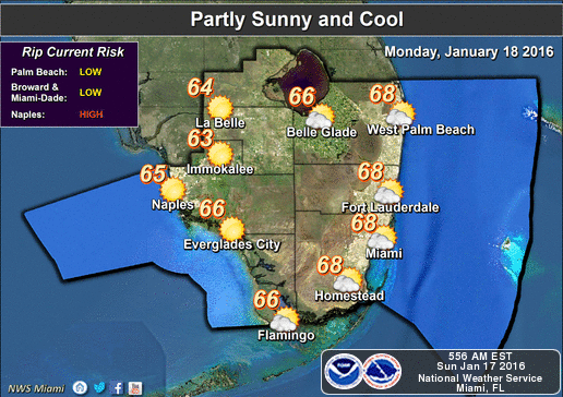 Monday morning will be much cooler, with lows in the low to mid 50s, and even with plenty of sun, temperatures will stall out in the upper 60s.
Tuesday will be cold by South Florida standards, with lows in the low 50s and highs in the mid to upper 60s on a sunny afternoon.
Wednesday morning lows will be in the low 50s, with a few colder readings inland, and highs will be in the upper 60s.
A slow warming trend begins on Thursday, with highs reaching the low to mid 70s, and some moisture will start to work its way into our area.
By Donna Thomas, SouthFloridaReporter.com Meteorologist, Jan. 17, 2016
Video from Henk Schorel,taken in south Miami-Dade county this morning.
[/vc_message]Disclaimer
Artificial Intelligence Disclosure & Legal Disclaimer
AI Content Policy.
To provide our readers with timely and comprehensive coverage, South Florida Reporter uses artificial intelligence (AI) to assist in producing certain articles and visual content.
Articles: AI may be used to assist in research, structural drafting, or data analysis. All AI-assisted text is reviewed and edited by our team to ensure accuracy and adherence to our editorial standards.
Images: Any imagery generated or significantly altered by AI is clearly marked with a disclaimer or watermark to distinguish it from traditional photography or editorial illustrations.
General Disclaimer
The information contained in South Florida Reporter is for general information purposes only.
South Florida Reporter assumes no responsibility for errors or omissions in the contents of the Service. In no event shall South Florida Reporter be liable for any special, direct, indirect, consequential, or incidental damages or any damages whatsoever, whether in an action of contract, negligence or other tort, arising out of or in connection with the use of the Service or the contents of the Service.
The Company reserves the right to make additions, deletions, or modifications to the contents of the Service at any time without prior notice. The Company does not warrant that the Service is free of viruses or other harmful components.

")
")


")