

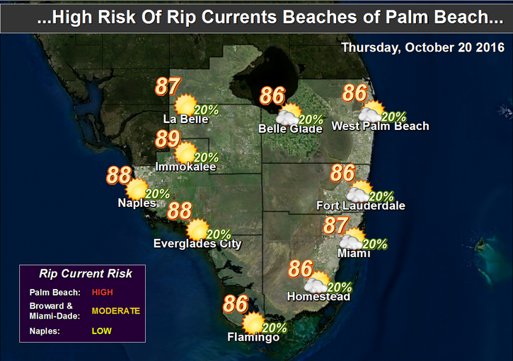
 South Florida will see sun, clouds, and a few quick showers on Thursday as we wait for a cold front this weekend. Thursday also brings a medium risk of dangerous rip currents at the beaches in Miami-Dade and Broward, and highs in the mid to upper 80s.
 We’ll do it again on Friday in advance of the front, so look for the chance of a shower or two, a medium risk of dangerous rip currents at the Atlantic beaches, and highs mostly in the mid 80s.


The front moves through overnight, so we could see an isolated early shower on Saturday, followed by sun and fewer clouds. Saturday’s highs will be in the low to mid 80s.
Sunday will be pleasant, with morning lows near 70 degrees, sun and clouds, and afternoon highs in the low 80s.
Monday will be seasonable as well, with lows around the 70 degree mark, highs in the low 80s, plenty of sun, and clouds on a building ocean breeze.
 In the tropics, the disturbance well to our east has a medium chance of becoming a tropical or subtropical depression over the next few days. It’s no threat to South Florida, because the cold front will sweep it to the northeast this weekend.
Disclaimer
Artificial Intelligence Disclosure & Legal Disclaimer
AI Content Policy.
To provide our readers with timely and comprehensive coverage, South Florida Reporter uses artificial intelligence (AI) to assist in producing certain articles and visual content.
Articles: AI may be used to assist in research, structural drafting, or data analysis. All AI-assisted text is reviewed and edited by our team to ensure accuracy and adherence to our editorial standards.
Images: Any imagery generated or significantly altered by AI is clearly marked with a disclaimer or watermark to distinguish it from traditional photography or editorial illustrations.
General Disclaimer
The information contained in South Florida Reporter is for general information purposes only.
South Florida Reporter assumes no responsibility for errors or omissions in the contents of the Service. In no event shall South Florida Reporter be liable for any special, direct, indirect, consequential, or incidental damages or any damages whatsoever, whether in an action of contract, negligence or other tort, arising out of or in connection with the use of the Service or the contents of the Service.
The Company reserves the right to make additions, deletions, or modifications to the contents of the Service at any time without prior notice. The Company does not warrant that the Service is free of viruses or other harmful components.


")