

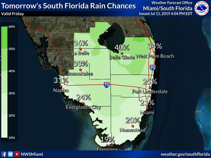
 South Florida will see a summer day of hot sun and passing showers, while Tropical Storm Barry is on the move in the northeastern Gulf of Mexico. Here at home, Friday features a mix of hot sun and some clouds, with showers and a few storms in the afternoon. Highs on Friday will be in the low 90s, but sticky conditions will make it feel about 10 degrees hotter.
Saturday will bring good sun, some clouds, and mostly Gulf coast showers and storms in the afternoon. Saturday’s highs will be in the low 90s.
The Gulf coast and interior will deal with periods of showers and storms on Sunday, while the east coast metro area will see a mix of sun and clouds with a few passing showers. Sunday’s highs will be in the low 90s.
Look for more widespread showers and storms on Monday, with the Gulf coast and interior again seeing the most activity. Monday’s highs will be in the low 90s.

Tuesday will feature good sun, some clouds, and passing showers and storms. Highs on Tuesday will be in the low 90s.
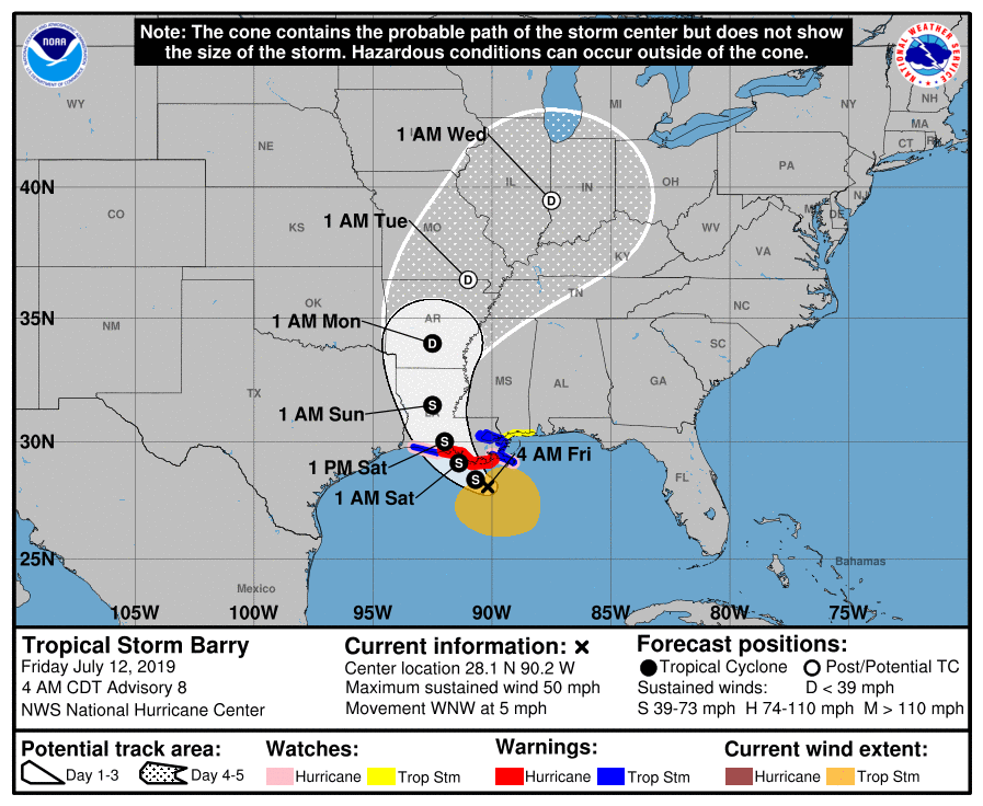 Tropical Storm Barry is expected to strengthen to a hurricane before making landfall on Saturday, but the northern Gulf coast will deal with heavy rain, gusty winds, and storm surge on Friday. Barry will bring extremely heavy rainfall to Louisiana and then work its way northward in the Mississippi River valley, dumping up to 15 inches of rain through the early portions of next week.
 We’re also tracking a disorganized tropical wave that is located several hundred
miles southwest of the Cabo Verde Islands.
Disclaimer
Artificial Intelligence Disclosure & Legal Disclaimer
AI Content Policy.
To provide our readers with timely and comprehensive coverage, South Florida Reporter uses artificial intelligence (AI) to assist in producing certain articles and visual content.
Articles: AI may be used to assist in research, structural drafting, or data analysis. All AI-assisted text is reviewed and edited by our team to ensure accuracy and adherence to our editorial standards.
Images: Any imagery generated or significantly altered by AI is clearly marked with a disclaimer or watermark to distinguish it from traditional photography or editorial illustrations.
General Disclaimer
The information contained in South Florida Reporter is for general information purposes only.
South Florida Reporter assumes no responsibility for errors or omissions in the contents of the Service. In no event shall South Florida Reporter be liable for any special, direct, indirect, consequential, or incidental damages or any damages whatsoever, whether in an action of contract, negligence or other tort, arising out of or in connection with the use of the Service or the contents of the Service.
The Company reserves the right to make additions, deletions, or modifications to the contents of the Service at any time without prior notice. The Company does not warrant that the Service is free of viruses or other harmful components.


")

