

 Monday features plenty of hot sun in the morning, with a few east coast showers. Then look for widespread showers and storms in the afternoon. Highs on Monday will be in the low 90s — but it will feel like 100 degrees during much of the afternoon.
LIVE RADAR 24/7 (Click Here Then Press Play)
Tuesday will kick off the month of September with mostly sunny skies in the morning and periods of showers and storms in the afternoon. Tuesday’s highs will be in the low 90s.
Wednesday will bring plenty of sun and mid to late afternoon showers and storms. Wednesday’s highs will be in the low 90s.

Thursday will feature good sun and a few east coast showers in the morning. Showers and storms will pop up in the afternoon, and a brisk breeze will develop in the east coast metro area. Thursday’s highs will be in the low 90s.
Friday’s forecast calls for a mix of sun, clouds, and a few showers. Highs on Friday will be in the low 90s again.
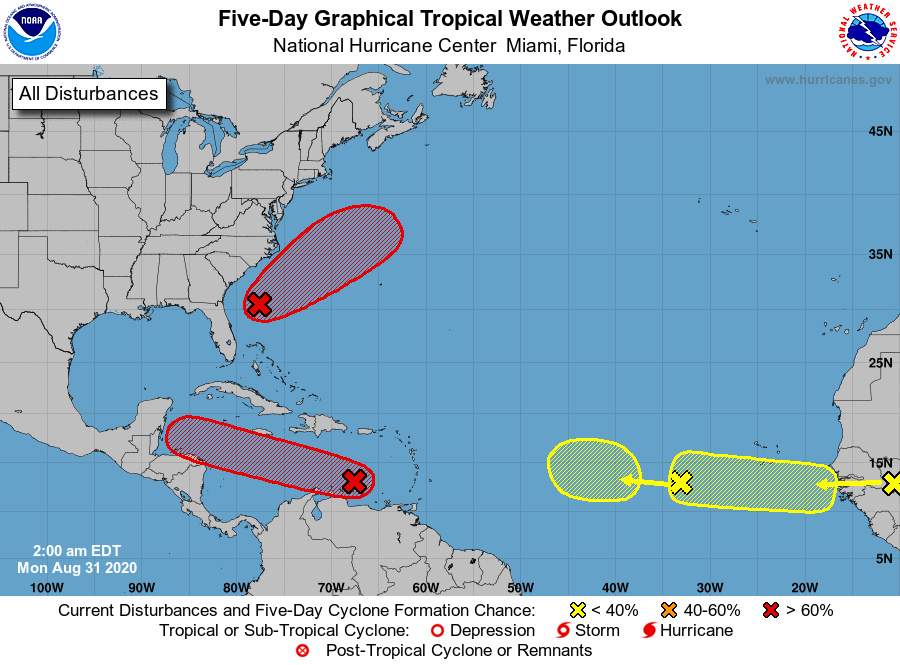 In the tropics, a low about 300 miles east of Jacksonville doesn’t have a lot of showers associated with it yet but will have a high chance of becoming a depression in a few days. This feature is forecast to move away from land and into the open Atlantic. A wave in the eastern Caribbean has a high chance of developing into a depression by midweek. And a wave moving through the eastern Atlantic has a low chance of developing. Finally, we’ll be watching the African coast later this week for the emergence of yet another wave.
Disclaimer
Artificial Intelligence Disclosure & Legal Disclaimer
AI Content Policy.
To provide our readers with timely and comprehensive coverage, South Florida Reporter uses artificial intelligence (AI) to assist in producing certain articles and visual content.
Articles: AI may be used to assist in research, structural drafting, or data analysis. All AI-assisted text is reviewed and edited by our team to ensure accuracy and adherence to our editorial standards.
Images: Any imagery generated or significantly altered by AI is clearly marked with a disclaimer or watermark to distinguish it from traditional photography or editorial illustrations.
General Disclaimer
The information contained in South Florida Reporter is for general information purposes only.
South Florida Reporter assumes no responsibility for errors or omissions in the contents of the Service. In no event shall South Florida Reporter be liable for any special, direct, indirect, consequential, or incidental damages or any damages whatsoever, whether in an action of contract, negligence or other tort, arising out of or in connection with the use of the Service or the contents of the Service.
The Company reserves the right to make additions, deletions, or modifications to the contents of the Service at any time without prior notice. The Company does not warrant that the Service is free of viruses or other harmful components.


