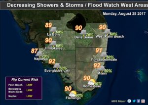
 South Florida will still see some storms continue on Monday as the nation’s attention focuses on the flooding disaster in Houston and surrounding areas in Texas. Here at home, Monday will bring a mix of sun and clouds, but we’ll also see storms move through in the afternoon. Highs on Monday will be in the low 90s.
Our normal summer pattern returns on Tuesday, so look for a few early coastal showers, a mix of sun and clouds, and afternoon storms in spots as the sea breeze moves inland. Tuesday’s highs will be mostly in the low 90s, but some locations could hit the mid 90s.
Wednesday will bring a mix of sun and clouds, along with afternoon storms in spots. Wednesday’s highs will be in the low 90s.
Thursday features more of the same — a mix of sun and clouds and scattered afternoon storms. Thursday’s highs will be in the low 90s.
Friday kicks off the month of September with more summerlike weather — a few coastal showers to start, a mix of sun and clouds, and afternoon storms in spots. Highs on Friday will be in the low 90s.
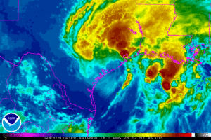 Tropical Storm Harvey remains virtually parked on the Texas coast and continues to drop incredible amounts of rain. At 5 am Monday, Harvey was located near 28.6 North, 96.3 West, and was moving southeast at just 3 miles per hour. Maximum sustained winds were 40 miles per hour. Harvey is forecast to remain near the Houston area before finally moving well inland at a more rapid pace — but not before dumping another 20 inches or more of rain. While the flooding in parts of Houston is already at epic and heartbreaking levels, the full scope of this disaster remains to be seen.
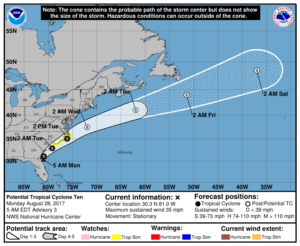 The low we’ve been watching is now Potential Tropical Cyclone # 10. At 5 am Monday, it was located near 30.3 North, 81.0 West, and was nearly stationary. Maximum sustained winds were 35 miles per hour. The system is expected to clip the Carolina coast, bringing high surf, gusty winds, and rain during the next few days.
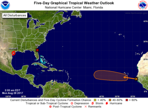 Finally, a wave in the eastern Atlantic has a medium chance of developing into a depression during the next 5 days.
Disclaimer
Artificial Intelligence Disclosure & Legal Disclaimer
AI Content Policy.
To provide our readers with timely and comprehensive coverage, South Florida Reporter uses artificial intelligence (AI) to assist in producing certain articles and visual content.
Articles: AI may be used to assist in research, structural drafting, or data analysis. All AI-assisted text is reviewed and edited by our team to ensure accuracy and adherence to our editorial standards.
Images: Any imagery generated or significantly altered by AI is clearly marked with a disclaimer or watermark to distinguish it from traditional photography or editorial illustrations.
General Disclaimer
The information contained in South Florida Reporter is for general information purposes only.
South Florida Reporter assumes no responsibility for errors or omissions in the contents of the Service. In no event shall South Florida Reporter be liable for any special, direct, indirect, consequential, or incidental damages or any damages whatsoever, whether in an action of contract, negligence or other tort, arising out of or in connection with the use of the Service or the contents of the Service.
The Company reserves the right to make additions, deletions, or modifications to the contents of the Service at any time without prior notice. The Company does not warrant that the Service is free of viruses or other harmful components.


