

By Donna Thomas, SouthFloridaReporter.com Meteorologist, Aug 23, 2015 – South Florida will see early showers and some afternoon storms on Sunday, while Tropical Storm Danny weakens as it approaches the Leeward Islands. Our Sunday will feature those early showers, highs in the muggy low to mid 90s, and some afternoon storms, mostly inland and in the western suburbs. Look for a few early showers on Monday as school buses roll again, and the first day of school will bring highs mostly in the sticky low 90s and just a stray afternoon storm. We’ll see some afternoon storms and highs in the low 90s on Tuesday. Rain chances will increase on Wednesday, and afternoon storms will be in the forecast through Friday, along with summertime highs in the low 90s.
Danny is now a tropical storm and will continue to weaken as it reaches the Leeward Islands. At 5 am Sunday, Danny was located near 15.8 North, 56.0 West and was moving  west at 15 miles per hour. Maximum sustained winds were 50 miles per hour. Danny continues to weaken as it encounters wind shear and dry air. Interaction with Puerto Rico and Hispaniola over the next couple of days is forecast to weaken it further to depression strength, but it does pose the threat of mudslides on both islands. Danny could become a remnant low before reaching Hispaniola, and in any case, its expected to dissipate by Friday, well southeast of South Florida. We’ll continue to watch Danny to make sure it follows the script.
Elsewhere in the tropics, the wave about 500 miles south-southwest of the Cape Verde Islands is looking healthy as it moves quickly westward. The National Hurricane Center gives it a medium chance of becoming a depression by Tuesday and a high chance of 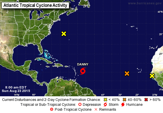 reaching that strength within 5 days. The low northwest of Bermuda has only a low chance of developing, and another wave just coming off the African coast has a low chance of developing over the next couple of days, at least until it reaches areas more favorable for development.
Disclaimer
Artificial Intelligence Disclosure & Legal Disclaimer
AI Content Policy.
To provide our readers with timely and comprehensive coverage, South Florida Reporter uses artificial intelligence (AI) to assist in producing certain articles and visual content.
Articles: AI may be used to assist in research, structural drafting, or data analysis. All AI-assisted text is reviewed and edited by our team to ensure accuracy and adherence to our editorial standards.
Images: Any imagery generated or significantly altered by AI is clearly marked with a disclaimer or watermark to distinguish it from traditional photography or editorial illustrations.
General Disclaimer
The information contained in South Florida Reporter is for general information purposes only.
South Florida Reporter assumes no responsibility for errors or omissions in the contents of the Service. In no event shall South Florida Reporter be liable for any special, direct, indirect, consequential, or incidental damages or any damages whatsoever, whether in an action of contract, negligence or other tort, arising out of or in connection with the use of the Service or the contents of the Service.
The Company reserves the right to make additions, deletions, or modifications to the contents of the Service at any time without prior notice. The Company does not warrant that the Service is free of viruses or other harmful components.
")


")

