

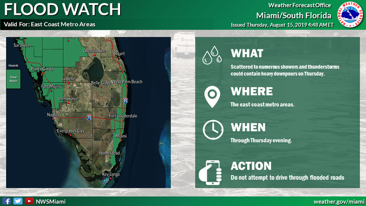
 Showers and storms will be around South Florida on Thursday, and a flood watch is in effect for metro Broward and much of the Miami-Dade metro area through the evening hours. Thursday features sun and clouds to start, with showers and storms developing from midday onward. We could see heavy downpours in spots, which would lead to localized flooding in portions of the east coast metro area. Highs on Thursday will be in the low 90s, but it will feel quite a bit hotter with high humidity levels.
Friday will be another day of sun, clouds, showers, and storms, with somewhat greater storm coverage over the western part of our area. Friday’s highs will be in the low 90s.
Look for more of the same on Saturday — sun, clouds, and building showers and storms in the afternoon. Saturday’s highs will be in the low 90s.
Sunday will feature sun and clouds to start, with showers and storms returning in the afternoon. Sunday’s highs will be in the low 90s.

Monday’s forecast includes sun, clouds, and afternoon showers and storms. Highs on Monday will be in the low 90s.
We’re not expecting any developments in the tropical Atlantic for at least the next several days.
Disclaimer
Artificial Intelligence Disclosure & Legal Disclaimer
AI Content Policy.
To provide our readers with timely and comprehensive coverage, South Florida Reporter uses artificial intelligence (AI) to assist in producing certain articles and visual content.
Articles: AI may be used to assist in research, structural drafting, or data analysis. All AI-assisted text is reviewed and edited by our team to ensure accuracy and adherence to our editorial standards.
Images: Any imagery generated or significantly altered by AI is clearly marked with a disclaimer or watermark to distinguish it from traditional photography or editorial illustrations.
General Disclaimer
The information contained in South Florida Reporter is for general information purposes only.
South Florida Reporter assumes no responsibility for errors or omissions in the contents of the Service. In no event shall South Florida Reporter be liable for any special, direct, indirect, consequential, or incidental damages or any damages whatsoever, whether in an action of contract, negligence or other tort, arising out of or in connection with the use of the Service or the contents of the Service.
The Company reserves the right to make additions, deletions, or modifications to the contents of the Service at any time without prior notice. The Company does not warrant that the Service is free of viruses or other harmful components.


")
")
")


")

