

 Thursday features early showers with quick downpours in spots. Then we’ll see periods of sun and clouds, and plenty of showers and storms will develop during the afternoon, especially along the Gulf coast. Highs on Thursday will be in the upper 80s close to the Atlantic coast and the low 90s elsewhere.
LIVE RADAR 24/7 (Click Here Then Press Play)
Friday will bring a mix of sun and clouds in the morning, followed by widespread showers and a few storms in the afternoon. Friday’s highs will be in the low 90s.
Saturday will start with good sun and some clouds, and showers and storms will develop in the mid to late afternoon. Saturday’s highs will be in the low 90s.

Sunday will feature some sun, more clouds, and widespread showers and a few storms in the afternoon. Sunday’s highs will be near 90 degrees.
Monday’s forecast includes early sun and clouds with plenty of showers and storms in the afternoon. Highs on Monday will be in the low 90s.
In the tropics, we’ll keep an eye on an area of showers and storms east of the Bahamas. This feature will move over portions of South Florida on Friday, but it is not expected to develop into a depression by that time. It does have a low chance of developing once it reaches the eastern Gulf of Mexico.
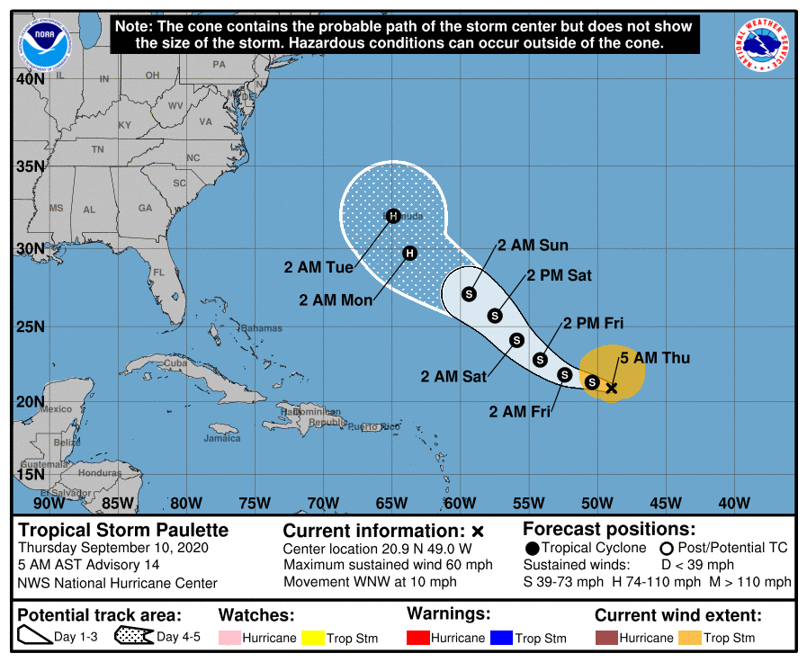 We also continue to track two tropical storms in the Atlantic. Tropical Storm Paulette could move near or over Bermuda early next week. At 5 am Thursday, Paulette was located near 20.9 North, 49.0 West, about 1250 miles southeast of Bermuda. Paulette was moving west-northwest at 10 miles per hour and had maximum sustained winds of 60 miles per hour. Paulette is now forecast to be a hurricane as it nears Bermuda. In the eastern Atlantic, Tropical Storm Rene is also expected to reach hurricane strength eventually but stay over the open Atlantic. At 5 am Thursday, Rene was located near 18.2 North, 34.8 West, and was moving west-northwest at 10 miles per hour. Rene’s maximum sustained winds were 40 miles per hour.
 Elsewhere, the low that’s now within a few hundred miles of the North Carolina coast has a low chance of becoming a depression before coming ashore on Thursday afternoon. The wave moving from Africa into the eastern Atlantic has a high chance of becoming a depression during the next couple of days. Finally, yet another disturbance over Africa will reach the eastern Atlantic in a couple of days. This wave has a low chance of developing in the next five days.
Disclaimer
Artificial Intelligence Disclosure & Legal Disclaimer
AI Content Policy.
To provide our readers with timely and comprehensive coverage, South Florida Reporter uses artificial intelligence (AI) to assist in producing certain articles and visual content.
Articles: AI may be used to assist in research, structural drafting, or data analysis. All AI-assisted text is reviewed and edited by our team to ensure accuracy and adherence to our editorial standards.
Images: Any imagery generated or significantly altered by AI is clearly marked with a disclaimer or watermark to distinguish it from traditional photography or editorial illustrations.
General Disclaimer
The information contained in South Florida Reporter is for general information purposes only.
South Florida Reporter assumes no responsibility for errors or omissions in the contents of the Service. In no event shall South Florida Reporter be liable for any special, direct, indirect, consequential, or incidental damages or any damages whatsoever, whether in an action of contract, negligence or other tort, arising out of or in connection with the use of the Service or the contents of the Service.
The Company reserves the right to make additions, deletions, or modifications to the contents of the Service at any time without prior notice. The Company does not warrant that the Service is free of viruses or other harmful components.


