Home Weather Sat UPDATE #2: Powerful Dorian Evan Stronger

Sat UPDATE #2: Powerful Dorian Evan Stronger

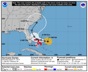
  Powerful Hurricane Dorian is even stronger late Saturday morning as it takes aim on the northwestern Bahamas.  Here in South Florida, we’re seeing additional changes in Dorian’s forecast track.

Keep informed with our interactive page
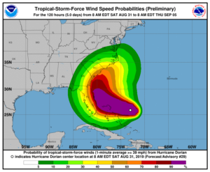
At 11 am Saturday, Dorian’s maximum sustained winds were 150 miles per hour  Dorian was located near 26.0 North, 73.4 West, about 415 miles east of West Palm Beach and 260 miles east-northeast of the northwestern Bahamas.  The hurricane is moving west and has slowed to 8 miles per hour.

A hurricane warning is in effect for most of the northwestern Bahamas, and conditions there will deteriorate later on Saturday.  All preparations should be rushed to completion.  This is likely to be a very bad hurricane event for portions of the northwestern Bahamas when Dorian moves in on Sunday.
Faith Based Events

Computer models are in agreement in turning Dorian northward far enough east from the coast of Miami-Dade and Broward that the probability of hurricane force winds has dropped significantly with the 11 am advisory.  Palm Beach County, because of its geography, is at greater risk and remains in the cone as of 11 am Saturday — the only part of South Florida to do so.  The risk of significant impacts remains for the coastal area north of West Palm Beach through the Space Coast.

In South Florida, expect tropical storm force winds, the chance of hurricane force gusts in portions of the east coast metro area, periods of heavy rain, and dangerous swells and flooding along the Atlantic coast, from Sunday night through Monday.  We should see slow improvement on Tuesday as Dorian pulls away to the north.

If you are in Palm Beach County and the northern part of Broward, you should put up shutters.  If you live elsewhere in the east coast metro area or along the Gulf coast, shutters are optional.  Since we will get gusty winds strong enough to damage power lines and trees, power outages are likely late Sunday through Monday, so plan accordingly.

Additional information will be posted after the 5 pm Saturday advisory package from the National Hurricane Center.

[vc_message message_box_style=”solid-icon” message_box_color=”blue”]By Donna Thomas, SouthFloridaReporter.com, certified Meteorologist, Aug. 31, 2019[/vc_message]

Disclaimer

The information contained in South Florida Reporter is for general information purposes only.
The South Florida Reporter assumes no responsibility for errors or omissions in the contents of the Service.
In no event shall the South Florida Reporter be liable for any special, direct, indirect, consequential, or incidental damages or any damages whatsoever, whether in an action of contract, negligence or other tort, arising out of or in connection with the use of the Service or the contents of the Service. The Company reserves the right to make additions, deletions, or modifications to the contents of the Service at any time without prior notice.
The Company does not warrant that the Service is free of viruses or other harmful components


Donna Thomas has studied hurricanes for two decades. She holds a PhD in history when her experience with Hurricane Andrew ultimately led her to earn a degree in broadcast meteorology from Mississippi State University. Donna spent 15 years at WFOR-TV (CBS4 in Miami-Fort Lauderdale), where she worked as a weather producer with hurricane experts Bryan Norcross and David Bernard. She also produced hurricane specials and weather-related features and news coverage, as well as serving as pool TV producer at the National Hurricane Center during the 2004 and 2005 seasons. Donna also served as a researcher on NOAA's Atlantic Hurricane Database Reanalysis Project. Donna specializes in Florida's hurricane history.