

 Monday features windy conditions, storms, and showers as the season’s first front moves through. A high risk of dangerous rip currents remains at the Atlantic beaches, thanks to swells from Hurricane Teddy. Minor flooding is likely along the Atlantic coast. Highs on Monday will be mostly in the mid-80s.
LIVE RADAR 24/7 (Click Here Then Press Play)
Tuesday will bring mostly sunny skies and breezy conditions, with a few afternoon showers in the east coast metro area. Tuesday’s highs will be in the mid-80s — with lower humidity than we’ve experienced in a while.
Wednesday will see good sun, a few clouds on a brisk ocean breeze, and some afternoon showers in spots. Wednesday’s highs will be in the upper 80s.

Thursday will feature a mix of sun and clouds alternating with periods of showers and storms. Thursday’s highs will be mostly in the upper 80s.
Friday’s forecast includes lots of clouds and widespread showers and storms. Highs on Friday will be in the upper 80s.
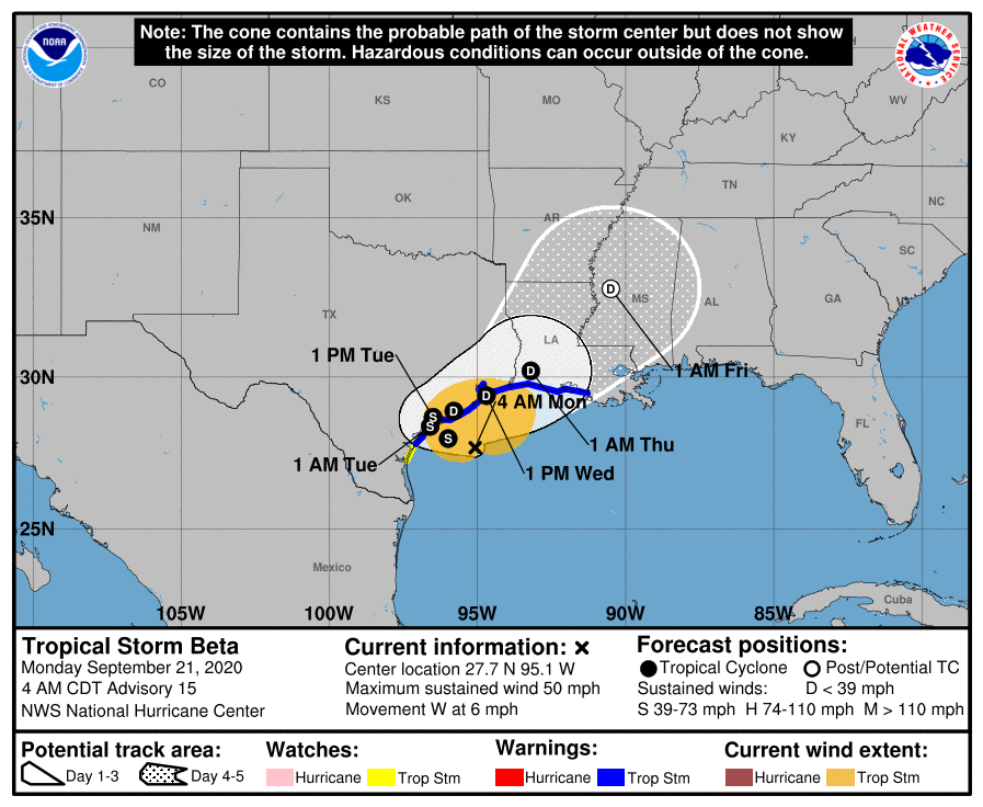 In the tropics, Tropical Storm Beta will affect portions of Texas starting on Monday morning. At 5 am, Beta was located near 27.7 North, 95.1 West, about 110 miles south of Galveston, Texas, Maximum sustained winds were 50 miles per hour, and Beta was moving west at 6 miles per hour. Eastern Texas and western Louisiana can expect up to 10 inches of rain from this slow-moving system.
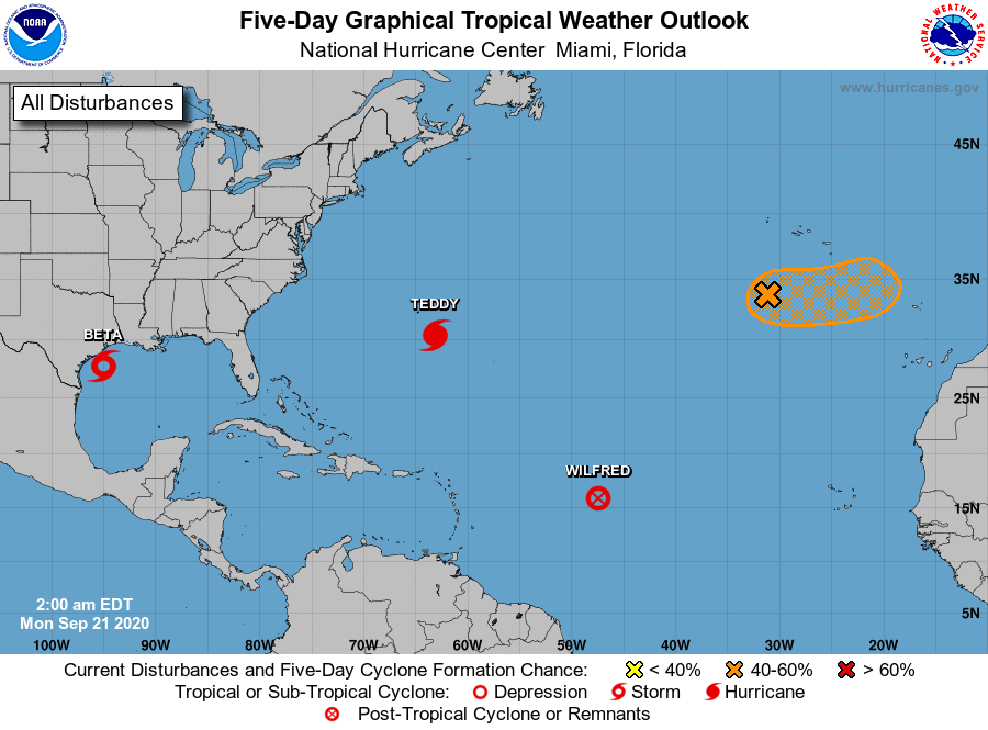 Hurricane Teddy was about 165 miles southeast of Bermuda early on Monday. At 5 am, Teddy was located near 30.3 North, 60.2 West, and was moving north at 9 miles per hour. Maximum sustained winds were 100 miles per hour. Tropical storm watches are now up for portions of the Canadian Maritimes. Teddy will create swells and generate rip currents along the U.S. east coast, including Florida.
Elsewhere, Wilfred is now a trough of low pressure in the open Atlantic. Finally, Extratropical Cyclone Paulette has a medium chance of regaining some tropical characteristics a few hundred miles south of the Azores.
Disclaimer
Artificial Intelligence Disclosure & Legal Disclaimer
AI Content Policy.
To provide our readers with timely and comprehensive coverage, South Florida Reporter uses artificial intelligence (AI) to assist in producing certain articles and visual content.
Articles: AI may be used to assist in research, structural drafting, or data analysis. All AI-assisted text is reviewed and edited by our team to ensure accuracy and adherence to our editorial standards.
Images: Any imagery generated or significantly altered by AI is clearly marked with a disclaimer or watermark to distinguish it from traditional photography or editorial illustrations.
General Disclaimer
The information contained in South Florida Reporter is for general information purposes only.
South Florida Reporter assumes no responsibility for errors or omissions in the contents of the Service. In no event shall South Florida Reporter be liable for any special, direct, indirect, consequential, or incidental damages or any damages whatsoever, whether in an action of contract, negligence or other tort, arising out of or in connection with the use of the Service or the contents of the Service.
The Company reserves the right to make additions, deletions, or modifications to the contents of the Service at any time without prior notice. The Company does not warrant that the Service is free of viruses or other harmful components.


